 Washington : Safety by City
- Anacortes
- Bainbridge Island
- Bellevue
- Diablo
- Forks
- Gig Harbor
- Kennewick
- Kent
- Kettle Falls
- Longview
- Mercer Island
- Moses Lake
- Neah Bay
- Ocean Shores
- Olympia
- Port Angeles
- Port Townsend
- Poulsbo
- Pullman
- Quinault
- Renton
- San Juan Islands
- Seabrook
- Seattle
- Sequim
- Snoqualmie
- Spokane
- Spokane Valley
- Tacoma
- Walla Walla
- Wenatchee
- Westport
- Yakima
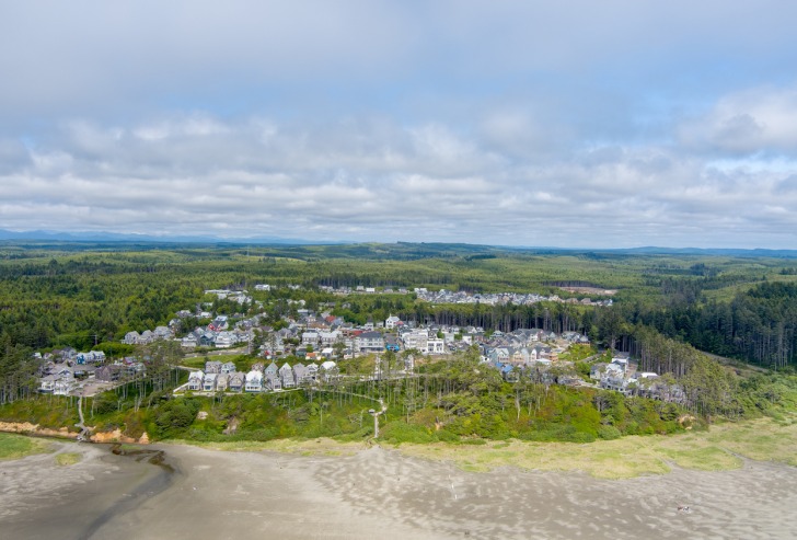
Seabrook, Washington, is like no other beach town in the Pacific Northwest by many comparisons.
In this hamlet, everything is intentionally planned to maximize and amplify your vacation experience.
Seabrook is built on a concept called New Urbanism, while very little about it feels urban.
Even the Town Hall is nothing more than an event venue.
Stores and restaurants are carefully approved to avoid redundancy.
Founded in 2004, it’s designed to evoke the feel of a classic American beach town.
Micro neighborhoods are built to embrace nature while encouraging walkability and individuality in each one.
The center of Seabrook is no more than 1,500 feet from the stunning beach of the Washington coastline.
While Seabrook itself offers plenty to keep you entertained, it’s also conveniently located for exploring other nearby attractions.
The Olympic Peninsula, with its stunning national parks and diverse ecosystems, is just a short drive away, providing even more opportunities for adventure and exploration.
Warnings & Dangers in Seabrook

OVERALL RISK: LOW
There's a low risk in Seabrook and a lot of natural wonders to see. We'll cover a handful of safety concerns in this article.

TRANSPORT & TAXIS RISK: LOW
Grays Harbor Transit has routes that run throughout the county, with one road zone that goes along Highway 109 at Seabrook. The town is designed to be walkable, but there is a taxi company specifically for Seabrook. If you are flying into and out of SeaTac, the community provides an airport shuttle.

PICKPOCKETS RISK: LOW
This is a low risk, with only three purse snatchings in the county in the past five years and 10 in the past decade. No pickpockets have been reported.

NATURAL DISASTERS RISK: MEDIUM
Seabrook faces natural disaster risks primarily from coastal erosion, earthquakes, wildfires, and tsunamis. Rogue waves can also happen, and there's a risk of high winds that can cause damage or knock you off your feet. Also, watch out for coastal flooding during the rainy season. It all comes together at a medium risk.

MUGGING RISK: LOW
Across the county, robbery rates are low, with about three to six happening each year going back a decade. That shouldn't make you careless, but it should give you a sense of safety and comfort.

TERRORISM RISK: LOW
This is a low risk due to the remote location from any potential hard target. You still want to report any suspicious activity as soon as possible.

SCAMS RISK: LOW
Check the Grays Harbor Sheriff's Office website and social media sites for the latest scams. Only rent homes through legitimate and official channels, like the Seabrook tourism site. The risk is low, but knowing the common tactics helps keep it that way.

WOMEN TRAVELERS RISK: LOW
This is another low-risk, with Seabrook being a safe place for women of all ages. The only caution would be to avoid hiking alone. Look for groups or guided tours if you're a solo traveler.

TAP WATER RISK: LOW
The U.S. has strict standards for tap water per the Safe Water Drinking Act. Communities are required to provide a Water Quality Report (Consumer Confidence Report) once a year by July 1. The latest reports from Seabrook show a consistent pattern of meeting or exceeding expectations.
Safest Places to Visit in Seabrook
Seabrook isn’t like most other cities and towns on the Olympic Peninsula.
Since it’s a planned community, it’s unincorporated and doesn’t have the traditional services of different cities.
The tourism site where you can learn more is seabrookwa.com.
Since the community of 550 (and growing) homes is self-sustained, anyone staying in a rental house here can use all the amenities of any neighborhood.
The Town Center is the heart of the community, with restaurants, shops, and Growler’s Alley common area.
The Farm District is where you can find the outdoor pool, game courts, and community garden.
Hiking, biking, and mixed-use trails surround Seabrook, covering 46 miles and reaching 4,452 feet in elevation.
Mocrocks Beach is just a few steps from Seabrook but spans about 10 miles from Copalis to Moclips.
The stunning beach is one of the best on the Pacific Northwest coastline and one of the best for clamming (razor clams are abundant).
Pacific Beach State Park is less than two miles north at the mouth of Joe Creek.
This is a great place to go camping if you’d like a night under the stars.
Seabrook is just 45 minutes from Lake Quinault, a glacially carved marvel at the crossroads of Olympic National Park and Olympic National Forest.
One must-see place is the Quinault Rainforest, where the world’s largest Sitka spruce tree stands 191 feet tall and is more than 58 feet in circumference.
Even if you aren’t up for hiking, the rainforest scenic drive offers views of waterfalls and massive trees along the 31-mile loop.
Route 109 along the water is known as the Hidden Coast Scenic Highway.
It runs for 41 miles from Grays Harbor to Tahola.
To explore more cities in Grays Harbor County, use the website visitinggraysharbor.com.
Seabrook is in the North Beaches region.
Twilight Saga fans might like to know that Forks, the setting for the books and films, is just two hours north.
To learn more about the history of this region, visit the Moclips-by-the-Sea Historical Society and Museum of the North Beach north of Seabrook or head south to the Aberdeen Museum of History.
Places to Avoid in Seabrook
While there’s not a dangerous part of Seabrook to avoid, I’m just going to be honest with you – you’ll either love Seabrook’s vibe or loathe it.
Those who aren’t fans of it use terms like “Stepford Wives,” “Truman Show,” and “creepy vibes.”
People who stayed there and loved it say it’s a welcoming community, has luxury accommodations, and is kid/pet-friendly.
If you want higher-end accommodations wrapped in a picture-perfect (albeit manufactured) package, Seabrook is the place to be.
It’s not a place to find affordable accommodations or the weathered and tattered places you’d expect on the raw Washington coastline.
However, Seabrook is the only one of its kind on this stretch of coastline, so if you’re looking for something more authentic, look to Pacific Beach, Ocean City, or Moclips.
Safety Tips for Traveling to Seabrook
- Seabrook doesn’t have a local police department. Law enforcement comes from the Grays Harbor Sheriff’s Office. You can follow them on Facebook @Grays-Harbor-Sheriffs-Office-100064419953166. Call (360) 249-3711 to get more information or ask specific safety questions.
- Sign up for Grays Harbor Emergency Alerts through the Reverse 911 program or the link on the county’s website. This will get you severe weather information and public safety hazards sent to your mobile device or email.
- Review the emergency management section of the county’s website to learn about tsunami safety and evacuation routes. You won’t have much time to act if a tsunami warning is issued, so know your escape route ahead of time.
- This area is popular for razor clam harvesting, but you’ll need a license from the Washington Department of Fish & Wildlife. Please know the season and limits for clamming.
- Call the 24-Hour Shellfish Safety Hotline at 800-562-5632 before you go digging. This can help avoid biotoxins, a dangerous bacterium that can’t be cooked out of clams and has no antidote if you consume infected clams. I’m writing this article in the heart of clamming season, and Seabrook’s beachfront is closed to clamming because of biotoxins.
- Some parts of the beach in this region are open to vehicle traffic, but that comes with a risk and a huge responsibility to protect your life and the vehicle. Please review the boundaries of where you can drive on the beach and how to prepare your car for the adventure.
- Knowing the tide charts is critical here, as it affects everything from trail access on beaches to clam beds. A website or app like Surfline is a great tool for knowing when the tide is rising or falling.
- Check the fire conditions before you even think about lighting a campfire or bonfire. Burn bans can go into effect at any time of the year but are more likely to occur in summer and fall.
- Both Olympic National Forest and Olympic National Park allow you to forage a certain amount of mushrooms, but you should study the mushroom guides on each website so you don’t pick up a bunch of poisonous ones.
- Check safety alerts and road closures through the National Park Service app or on the Forest Service website. Storms here, like powerful atmospheric rivers in winter, can wash out roads, send debris over trails, and leave sections underwater.
So... How Safe Is Seabrook Really?
Since Seabrook gets law enforcement from the county, there’s no way to check the crime rate in Seabrook vs the other cities with a total of 77,000 residents.
That said, crime rates across the county are incredibly low – like 86% lower than the national average.
Only about three thefts a week happen across the region.
The biggest safety risks are of the natural kind.
While the word “beach” might make you think of calm seas and beautiful, sunny days, this part of the country has unpredictable waves, lots of fog, enormous amounts of rain in the winter, and plenty of hazards.
Different sections of the coastline have different oversights.
In some cases, the state park governs the beach.
Others fall under the Washington Department of Fish & Wildlife.
The city, township, or tribal landowner might control some.
You control a lot of your safety by following guidelines, like wearing a life vest while kayaking, not climbing the rocks around waterfalls, and knowing the tide schedule.
Mobile service is limited in this region, so having a weather radio that is powered by batteries can be a literal lifesaver.
Overall, this is a wonderful area to visit if you respect the power of nature and plan accordingly.
How Does Seabrook Compare?
| City | Safety Index |
|---|---|
| Seabrook | 78 |
| Las Vegas | 62 |
| San Francisco | 61 |
| Philadelphia | 60 |
| Houston | 59 |
| Atlanta | 58 |
| St. Louis | 58 |
| Brussels (Belgium) | 60 |
| Shanghai (China) | 66 |
| Belize City (Belize) | 37 |
| La Paz (Bolivia) | 52 |
| Sao Paulo (Brazil) | 45 |
| Rio de Janeiro (Brazil) | 43 |
Useful Information

Visas
All international visitors need either a visa defining the purpose of the trip (tourist, work, school, etc.) or a visa waiver. Start the process using the Visa Wizard module on the U.S. State Department website. Also, your passport must be valid for at least six months after your trip, or you’ll need to apply for a new one.

Currency
Only the U.S. Dollar (USD) is accepted in the United States. International airports usually have a currency exchange desk on site, while regional airports won’t. Your home bank offers the lowest fees. For those using credit cards, check to see if there’s a foreign transaction fee. Credit cards, not debit cards, offer the best fraud protection.

Weather
Winters sticks to the mid-30s to upper 40s, with November through April being the wettest months. As one of the rainiest places in America, you should plan to bring waterproof clothing and accessories. Even at the peak of summer, highs rarely get out of the 70s, and cool nights drop into the 50s or 40s. Expect humid conditions year-round. Bring bug spray and sunscreen.

Airports
Seattle Tacoma International Airport is about 2.5 hours away. That's the closest and largest airport in the region. If you're staying in Seabrook, there is a shuttle to and from the airport for around $100 per person. Two pick-ups and drop-offs are scheduled daily.

Travel Insurance
Travel insurance protects the cost of baggage loss/theft, delays, cancelations, and emergency health issues. Rental car insurance should include roadside assistance and uninsured motorist coverage. Comprehensive insurance offers the best peace of mind.
Seabrook Weather Averages (Temperatures)
Average High/Low Temperature
| Temperature / Month | Jan | Feb | Mar | Apr | May | Jun | Jul | Aug | Sep | Oct | Nov | Dec |
|---|---|---|---|---|---|---|---|---|---|---|---|---|
| High °C | 8 | 9 | 12 | 14 | 17 | 19 | 22 | 22 | 21 | 15 | 11 | 8 |
| Low °C | 1 | 1 | 2 | 3 | 6 | 8 | 10 | 10 | 7 | 5 | 3 | 1 |
| High °F | 46 | 48 | 54 | 57 | 63 | 66 | 72 | 72 | 70 | 59 | 52 | 46 |
| Low °F | 34 | 34 | 36 | 37 | 43 | 46 | 50 | 50 | 45 | 41 | 37 | 34 |
Washington - Safety by City
| City | Safety Index |
|---|---|
| Anacortes | 82 |
| Bainbridge Island | 85 |
| Bellevue | 84 |
| Diablo | 78 |
| Forks | 85 |
| Gig Harbor | 75 |
| Kennewick | 40 |
| Kent | 42 |
| Kettle Falls | 78 |
| Longview | 82 |
| Mercer Island | 82 |
| Moses Lake | 46 |
| Neah Bay | 77 |
| Ocean Shores | 79 |
| Olympia | 57 |
| Port Angeles | 72 |
| Port Townsend | 81 |
| Poulsbo | 79 |
| Pullman | 79 |
| Quinault | 82 |
| Renton | 70 |
| San Juan Islands | 83 |
| Seabrook | 78 |
| Seattle | 55 |
| Sequim | 77 |
| Snoqualmie | 78 |
| Spokane | 74 |
| Spokane Valley | 62 |
| Tacoma | 38 |
| Walla Walla | 72 |
| Wenatchee | 80 |
| Westport | 78 |
| Yakima | 62 |
