 Wyoming : Safety by City
- Afton
- Alpine
- Casper
- Cheyenne
- Cody
- Dubois
- Gillette
- Guernsey
- Hulett
- Jackson Hole
- Laramie
- Lovell
- Lusk
- Pinedale
- Ranchester
- Rock Springs
- Saratoga
- Sheridan
- Sundance
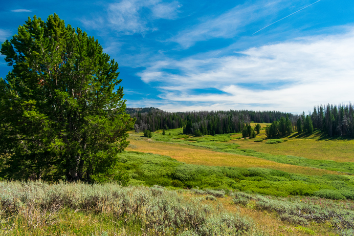
Ranchester, Wyoming, is a small, welcoming town that offers a quiet escape and easy access to the Bighorn Mountains.
Sitting at an elevation of 3,753 feet, this community of just over 1,000 residents is an ideal base for outdoor enthusiasts and history buffs, perched at a perfect stopping point between Yellowstone National Park; Billings, Montana; and the Black Hills of South Dakota.
Founded in the late 1800s, Ranchester grew as a railway town supporting the Northern Pacific Railroad.
Ranchester holds a deep connection to Wyoming’s ranching and pioneer heritage.
Its name is believed to reflect the area’s agricultural roots, combining “ranch” and “chester,” the latter being a common suffix for towns.
The town is just minutes from the Tongue River and the Bighorn National Forest, where visitors can enjoy fishing, hiking, and wildlife viewing in a less crowded setting than in other parts of Wyoming.
Plus, those who don’t want to deal with backroads or winding highways through mountains will appreciate the easy access point off Interstate 90.
Whether you’re drawn by the proximity to outdoor adventures or the chance to experience small-town Wyoming life, Ranchester offers an authentic slice of the state’s history and natural beauty without the expansive options in Montana just 10 miles north.
Warnings & Dangers in Ranchester

OVERALL RISK: LOW
The overall risk in Ranchester is low, as crime isn't a big problem here. Plus, those who love the outdoor beauty of Wyoming will appreciate all the options nearby.

TRANSPORT & TAXIS RISK: LOW
Ranchester doesn’t have public transportation, so visitors rely on cars to get around. Ride-sharing is minimal, but you can rent a car in nearby Sheridan, about 15 minutes away. The small-town setup makes walking easy for exploring the immediate area.

PICKPOCKETS RISK: LOW
The risk is low, but even with crime rates well below the national average, use smart safety steps like keeping wallets secured in front pants pockets or a hidden jacket pocket or locking car doors every time you park.

NATURAL DISASTERS RISK: LOW
Natural disasters are rare in Ranchester. Occasional flooding may occur along the Tongue River in spring, and wildfires can happen in dry summer months. Winter storms can be brutal if you aren't used to intense winters. However, stay weather-aware when visiting to ensure you keep that risk low.

MUGGING RISK: LOW
Robberies are also rare in Ranchester, but much like theft, basic common sense and security practices will go a long way.

TERRORISM RISK: LOW
Ranchester is a quiet, rural town with a very low terrorism risk. Staying aware of your surroundings is always smart, and the biggest risk (if you could call it that) would be on the interstate, where drugs or trafficking could be a problem since this is a major thoroughfare across the northern US.

SCAMS RISK: LOW
Scams are uncommon in Ranchester, but be cautious when booking accommodations online, as fake listings can pop up. Locals are typically helpful, so asking for advice about reputable businesses is a good idea. Check local police department and sheriff’s office social media sites for the latest scams. That will help keep the risk low.

WOMEN TRAVELERS RISK: LOW
The standard safety precautions go a long way here, so women won't need to worry about additional gender-based risks. I actually drove this length of I-90 across Montana and Wyoming a few years back as a solo female and had no issues.

TAP WATER RISK: LOW
The U.S. has strict standards for tap water per the Safe Water Drinking Act. Communities are required to provide a Water Quality Report (Consumer Confidence Report) once a year by July 1.
Safest Places to Visit in Ranchester
Manchester doesn’t have a separate tourism site, but you can get additional information on the Sheridan tourism site.
The city’s website also has a list of businesses.
Unlike many small towns in Wyoming, Ranchester doesn’t have a typical charming downtown collection of shops and restaurants.
With U.S. 14 running through the heart of the city, you will find plenty of places to get gas or food before heading to a wilderness destination or taking a scenic drive.
Ranchester has a visitor’s center where you can get brochures for tour guides and other seasonal activities.
Pretty much anything you can imagine here is possible – fishing, hiking, boating, hunting, skiing, and snowshoeing.
Connor Battlefield State Historic Site marks the spot of an 1865 clash between U.S. soldiers and Native American tribes.
It’s a peaceful place now, where you can walk the grounds, cast a line in the Tongue River, or spend a relaxing afternoon at the picnic areas and playground.
The Bighorn Highway (U.S. Route 14) spans about 58 miles from Ranchester to Shell, climbing over 9,000 feet at Granite Pass.
The route offers dramatic elevation changes, lush forests, and expansive views.
Key stops include Burgess Junction for visitor info, Shell Falls for breathtaking cascades, and scenic vistas around hairpin turns.
Another scenic drive option is to take the route on the west side of the Bighorn Mountains through Medicine Wheel Passage, where one of the oldest and most in-tact Indigenous artifacts still stands.
If you go that route, keep driving to Bighorn Lake National Recreation Area, part of Bighorn Canyon, which stretches over 70 miles.
Here, you can enjoy boating, fishing, and kayaking on its turquoise waters.
Located about 90 minutes from Ranchester, it features hiking trails, picnic spots, and stunning canyon views.
The Horseshoe Bend Marina is a popular access point for water activities.
The highway also opens the door to more than 1,200 miles of hiking trails throughout Bighorn National Forest.
Tongue River Canyon Trail is perfect for those who want to see Wyoming’s wildlife.
To learn more about the Sheridan area, read our article “How Safe Is Sheridan for Travel?”
Places to Avoid in Ranchester
You don’t need to be concerned about bad parts of town or dangerous neighborhoods here.
Those who are just stopping for gas or a meal in Ranchester should know that the truck stops are often crowded with people coming from all directions.
Always try to use a gas pump close to the entrance, as they are less likely to have card skimmers installed.
Lock your car while pumping gas or running inside for a bathroom break or snack.
One thing to note is that the T. Rex Natural History Museum is permanently closed.
This was once a big attraction in Ranchester, but there are other dinosaur museums across Wyoming.
Safety Tips for Traveling to Ranchester
- Law enforcement comes from the Sheridan County Sheriff’s Office. You can follow them on Facebook @sheridancountysheriffwy. Feel free to call (307) 672-3455 or email sheriff@scsowy.us with specific safety questions.
- Check the Forest Service’s website for Bighorn National Forest for alerts and closures before you visit. For example, the scenic road from Burgess Junction to Lovell is closed in winter. It usually runs from early December through Memorial Day.
- Enable Wireless Emergency Alerts (WEA) on your mobile device for updates on severe weather or emergencies. In areas with limited service, a NOAA weather radio provides reliable alerts. Tune to local frequencies or preset your radio for continuous updates.
- Ranchester has straightforward parking rules, but be mindful of posted signs. During snow emergencies, parking on some streets may be restricted for plowing. Check with local authorities or city websites for updates during the winter months.
- With elevations exceeding 9,000 feet in the Bighorns, altitude sickness can be a concern. Stay hydrated, ascend gradually, and avoid strenuous activity if you experience headaches or dizziness. Know your limits and descend if symptoms worsen.
- Wildlife such as bears, moose, and elk inhabit the area. Carry bear spray, avoid surprising animals, and secure all food and trash. Keep a safe distance, especially during calving or rutting seasons when animals can be aggressive.
- Mountain roads like U.S. 14 can have sharp curves, steep grades, and sudden weather changes. Always check Wyoming DOT road conditions online or by calling 511. Ensure your vehicle is equipped for high-altitude driving.
- Fishing in Wyoming requires a state fishing license, which can be purchased online or at local retailers. Be sure to check regulations for specific water bodies, including size and catch limits, before heading out.
- Wyoming requires a hunting license and proof of hunter safety education for most individuals. Licenses are available online or through retailers. Review seasonal regulations and mandatory safety zones before hunting on or near public lands. When in doubt, hire an outfitter to help you get the most out of the hunting experience while also being compliant with laws and regulations.
- The Ranchester area and Bighorn National Forest often experience strong winds, especially in open and elevated regions. These conditions can make driving on I-90 and scenic highways challenging, leading to reduced vehicle control and increased risk of accidents. High-profile vehicles like semi-trucks are particularly susceptible to wind-related issues. Give them plenty of space, and don’t tailgate. If you can’t see their side mirrors, the driver can’t see you.
So... How Safe Is Ranchester Really?
The Sheridan County Sheriff’s Office provides law enforcement here, as the city hasn’t had a local police department since 2015.
It will be interesting to see if this fast-growing city brings back local PD at a certain benchmark.
However, across the county, crime rates are low.
In 2021, the county saw 17 violent crimes, but by 2023, that number was down to four.
Even by early December 2024, the county was on pace to see fewer than eight.
Theft rates are low, with 36 reported in 2023.
Most of those were involved with “other” types of theft, not the petty theft that worries tourists.
By following common sense safety steps, like locking your car, you’ll have a safe and enjoyable experience in Ranchester, Wyoming.
It’s also helpful to know how to recreate in Wyoming responsibly by following the 7 Principles of Leave No Trace and keeping an eye on weather or fire dangers.
How Does Ranchester Compare?
| City | Safety Index |
|---|---|
| Ranchester | 80 |
| Philadelphia | 60 |
| Houston | 59 |
| Atlanta | 58 |
| St. Louis | 58 |
| Los Angeles | 56 |
| Oakland | 57 |
| La Paz (Bolivia) | 52 |
| Sao Paulo (Brazil) | 45 |
| Rio de Janeiro (Brazil) | 43 |
| Sofia (Bulgaria) | 73 |
| Siem Reap (Cambodia) | 63 |
| Phnom Penh (Cambodia) | 61 |
Useful Information

Visas
All international visitors need either a visa defining the purpose of the trip (tourist, work, school, etc.) or a visa waiver. Start the process using the Visa Wizard module on the U.S. State Department website. You can also download the CBP One mobile app to help on the go. Also, your passport must be valid for at least six months after your trip, or you’ll need to apply for a new one.

Currency
Only the U.S. Dollar (USD) is accepted in the United States. International airports usually have a currency exchange desk on site, while regional airports won’t. Your home bank offers the lowest fees. For those using credit cards, check to see if there’s a foreign transaction fee. Credit cards, not debit cards, offer the best fraud protection.

Weather
Ranchester sees cold winters and warm summers. Average snowfall is about 50 inches, with January lows around 15°F. Summer highs average in the mid-80s, making it a pleasant time to explore the outdoors.

Airports
The closest commercial airport is Sheridan County Airport, about 15 miles away, offering limited regional flights. For more options, Billings Logan International Airport is roughly 130 miles north and serves major airlines.

Travel Insurance
Travel insurance protects the cost of baggage loss/theft, delays, cancelations, and emergency health issues. Rental car insurance should include roadside assistance and uninsured motorist coverage. Comprehensive insurance offers the best peace of mind. Travel adventure insurance is a worthy investment if you plan to explore wilderness areas or do extensive backcountry trips.
Ranchester Weather Averages (Temperatures)
Average High/Low Temperature
| Temperature / Month | Jan | Feb | Mar | Apr | May | Jun | Jul | Aug | Sep | Oct | Nov | Dec |
|---|---|---|---|---|---|---|---|---|---|---|---|---|
| High °C | 3 | 3 | 9 | 13 | 19 | 26 | 31 | 30 | 24 | 16 | 9 | 2 |
| Low °C | -12 | -12 | -6 | -2 | 4 | 8 | 12 | 10 | 6 | -1 | -7 | -12 |
| High °F | 37 | 37 | 48 | 55 | 66 | 79 | 88 | 86 | 75 | 61 | 48 | 36 |
| Low °F | 10 | 10 | 21 | 28 | 39 | 46 | 54 | 50 | 43 | 30 | 19 | 10 |
Wyoming - Safety by City
| City | Safety Index |
|---|---|
| Afton | 82 |
| Alpine | 83 |
| Casper | 80 |
| Cheyenne | 81 |
| Cody | 80 |
| Dubois | 78 |
| Gillette | 83 |
| Guernsey | 78 |
| Hulett | 79 |
| Jackson Hole | 81 |
| Laramie | 85 |
| Lovell | 81 |
| Lusk | 82 |
| Pinedale | 75 |
| Ranchester | 80 |
| Rock Springs | 81 |
| Saratoga | 78 |
| Sheridan | 84 |
| Sundance | 80 |