 New Hampshire : Safety by City
- Derry
- Exeter
- Gorham
- Hampton Beach
- Hanover
- Keene
- Laconia
- LinWood
- Littleton
- Meredith
- Nashua
- North Conway
- Pembroke
- Piscataquog
- Pittsburg
- Sunapee
- West Lebanon
- Wolfeboro
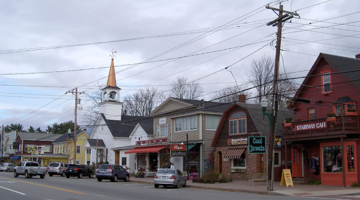
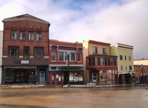
North Conway, New Hampshire, managed to have so many things to do packed into a small mountain town while still leaving plenty of breathing room.
It sits at the doorstep of White Mountain National Forest, covering more than 700,000 acres, and offers everything from outlet shopping to historic train rides to some of the best mountain skiing in the state.
North Conway is a village of Conway, a city that is just five miles south.
North Conway is much more of a tourist town, but both offer so many activities nearby in each season.
Conway is also at the beginning/end of the stunning Kancamagus Scenic Byway (aka The Kank), spanning 35 miles to Lincoln.
Covered bridges, ice caves, mountain trails, the Saco River, and Echo Lake State Park are on the activity list.
Even a Christmas-themed amusement park is just an hour away, but you can tell the kids that Santa’s Village moves to New Hampshire each summer.
The appeal in North Conway is as much about what’s in town as what you can find in the nearby cities.
It’s a great basecamp for the northern New Hampshire tapestry of small towns.
Warnings & Dangers in North Conway

OVERALL RISK: LOW
There's a low risk here statistically, but any tourism community is going to have the inherent potential for higher risks. Somehow, this area keeps a lower-than-average crime rate even with the thousands of people who visit each year.

TRANSPORT & TAXIS RISK: LOW
Tri-County Transit can get you between Conway, Moultonborough, Ossipee, and Wolfeboro, but you'll need a rental car to explore more. Taxis and rideshares are easy to find, but won't be the best economical decision if you want to explore the mountains.

PICKPOCKETS RISK: LOW
With just one purse snatching in the past five years across the entire town of Conway, it's a low risk. The potential is much higher, so keep all the standard theft safety steps in place.

NATURAL DISASTERS RISK: LOW
Buckle up for winter as nearby Mt. Washington is said to have the "Worst Weather in the World." Crews are quick to clear roads after major storms, but the intense winds, wet snow, and flooding potential will always take top priority. Severe weather in the summer can also keep the trails empty, but there aren't a lot of tornadoes here. Flash flooding is the biggest risk from spring through fall.

MUGGING RISK: LOW
The city averages about 2–4 robberies a year, and that includes Conway. The risk is low, but it's always smart to stay aware of your surroundings. There was an armed robbery in the parking lot of a local grocery store a few years back.

TERRORISM RISK: LOW
This is another low risk. It's a great place to visit, but so rural and remote outside the city limits. Mass shootings are all too common in America, but no place is immune. You can do your part by reporting any suspicious activity.

SCAMS RISK: LOW
This is another category with a statistically low risk but a potential for a higher one. The biggest concern should be rental homes and getting scammed out of money for a rental that doesn't exist. You can avoid this possible scam by asking for proof of renter's license, verifying the landlord is legit through the Chamber of Commerce, and avoiding requests to wire money.

WOMEN TRAVELERS RISK: LOW
Nothing in the crime data indicate women would be more at risk here, but you still want to follow all the personal safety steps you would in any tourist town.

TAP WATER RISK: LOW
The North Conway Water Precinct doesn't add chlorine to the water here, in case that's important to you. Only the pH balance is adjusted during the treatment process. The 2023 Water Quality Report was posted ahead of the June deadline and shows full compliance with no violations.
Safest Places to Visit in North Conway
NorthConwayNH.com is the tourism website for this village.
It does cover things to do in neighboring towns.
You can also review the WhiteMountains.com website for information about the region.
Look for the White Mountains Digital Guides and Brochures to download items without having to give personal information.
The scenic byways map is available in six languages.
Explore the charming downtown in North Conway Village while enjoying no sales tax on all purchases.
The Settler’s Green Outlet Village is a collection of outlet stores right in the center of town.
Embark on hiking trails like the popular Mount Washington Summit Trail or Diana’s Baths, a series of beautiful waterfalls.
Take the Mount Washington Auto Road for one of the steepest and deepest climbs your car will ever take.
You also have dozens of trails to explore in the area, some of which start right from the village.
Discover the fascinating world of weather at the Mount Washington Observatory.
This interactive museum will help you understand the elements that make Mount Washington home to some of the worst weather conditions on Earth.
North Conway is renowned for its winter sports opportunities.
Hit the slopes at Cranmore Mountain Resort, Attitash Mountain Resort, or Black Mountain Ski Area.
These resorts offer skiing, snowboarding, tubing, and other snow activities.
The Conway Scenic Railroad takes you back to a time when train travel was the only way to get here without a horse.
The routes go through the picturesque landscapes of the Mount Washington Valley.
Rides last anywhere from one to five hours.
The Saco (“SOCK-oh”) River is a popular warm-weather spot for tubing and kayaking.
You don’t have to go far to get access, as the Saco River Tubing Center is between Conway and North Conway.
The Eastern Slope Campgrounds are right by the center, and the river wraps around the western edge.
For rock climbers or those seeking breathtaking views, Cathedral Ledge State Park offers challenging routes and panoramic vistas of the surrounding mountains.
The view is just four miles from the village.
More rock climbing adventures await at Echo Lake State Park, where there’s a seasonal swimming beach.
New Hampshire has 54 covered bridges, and many of those are in the White Mountains region.
Check out the covered bridges guide on the Visit New Hampshire website to get a list and start planning your drive.
Places to Avoid in North Conway
North Conway doesn’t have bad parts of town or dangerous neighborhoods.
You can travel throughout the town without having to worry about rolling up your windows or locking doors while driving.
The only places to avoid in this region are greatly impacted by the weather, your experience levels, and your physical abilities.
It’s also important to research the risks as much as the places to visit.
For example, waterfalls in New Hampshire are stunning.
They are also filled with dangerous pressure points—slippery rocks, a misleading appearance of water depth below, the power of the current, etc.
It won’t happen to you?
Lisa Martin thought the same thing as she saw her eight-year-old sitting between two rocks get swept 12 feet down the waterfall.
Her son was fine.
The mother was devastated, as she had taken all kinds of precautions that day.
In 2023, two hikers misread the power of the incoming nor’easter and got stranded in heavy snow.
Rescuers spent all night trudging through two miles of deep snow to save them.
Even on sunny warm days, it’s easy to get turned around on the trailhead if you don’t know how to read the signs or navigate with a map when your mobile service fades.
Safety Tips for Traveling to North Conway
- Conway has a police department and provides law enforcement for North Conway. The phone number is (603) 356-5715 and the email address is police@conwaypdnh.gov.
- White Mountain National Forest is overseen by the Forest Service. There’s a visitor’s center in Conway. The phone number is (603) 447-5448.
- Always check the public notices and alerts of the mountains, rivers, and lakes using the social media sites for the Forest Service, town, emergency management, and county before taking an adventure.
- Do not judge the weather by the sky. Clear skies at the start of the day could still turn dark quickly as storms can approach from different directions here. High winds can make a hike brutal. The weather forecasts here come from the National Weather Service in Portland. The code for it is GYX.
- Use New England 511 to check road conditions throughout the area. You can also see live cameras, construction, and real-time traffic alerts.
- Anglers need a license from the New Hampshire Department of Fish & Game. You can purchase that online. Be sure to get the right type of water for your fishing license, as both freshwater and saltwater licenses are sold. All water in this region is freshwater.
- Stay on the trails. Going off the trails can lead to more accidents and exposure to natural risks like ticks, poison ivy, and snakes.
- When driving the road around here, you have to keep an eye out for moose. The risk becomes especially troublesome at night because moose are so tall that you won’t see their eyes reflecting as you do with a deer.
- Bring bear spray and bear-proof containers when you go in the woods. You’d be surprised how something as simple as a candy wrapper can attract a hungry bear. Never feed or move closer to wildlife.
- Conway has grown so fast over the past few years that the town has put a stop to building under a new town plan is created. That’s going to mean a lot of traffic as the roads weren’t built to handle this many people.
So... How Safe Is North Conway Really?
Since North Conway is a village of Conway, the only official crime data we have is for the entire city.
On top of that, crime rates are calculated based on the number of crimes vs. population, which doesn’t account for the thousands of tourists that come through each year.
Even trying to find reports of crimes in North Conway isn’t easy, be it from newspapers, local television stations, or even the police department’s social media sites.
In fact, most newspaper reports about North Conway celebrate people doing nice things instead of breaking the law.
Half the thefts over the past five years were related to shoplifting.
While that generally doesn’t impact a visitor, it does indicate there are people capable of stealing around you.
Basic common sense will go a long way here.
The outdoor safety risks are where the REALLY is in your corner.
Knowing winter weather safety, wilderness survival, how to remove ticks, and using a compass/paper map to get around will help keep you safe in the White Mountains.
While no town is safe enough to let your guard down, you can definitely let your hair down here and have a relaxing or invigorating time.
How Does North Conway Compare?
| City | Safety Index |
|---|---|
| North Conway | 76 |
| Philadelphia | 60 |
| Houston | 59 |
| Atlanta | 58 |
| St. Louis | 58 |
| Los Angeles | 56 |
| Oakland | 57 |
| La Paz (Bolivia) | 52 |
| Sao Paulo (Brazil) | 45 |
| Rio de Janeiro (Brazil) | 43 |
| Sofia (Bulgaria) | 73 |
| Siem Reap (Cambodia) | 63 |
| Phnom Penh (Cambodia) | 61 |
Useful Information

Visas
Visitors coming from outside the country will need a passport and visa or visa waivers. You can see which visa option is right for you by using the Visa Wizard on the U.S. State Department website. Tourist visas take the longest, so start planning early.

Currency
Only the U.S. Dollar currency will be used here. There is a Western Union in North Conway if you want to send your currency exchange there, but your local bank will have lower fees.

Weather
Four beautiful seasons will greet you here, but overpack on cold weather clothing since summer nights can be chilly. Winter is intense, so don't skimp accessories. Bring sunscreen and bug spray. Don't buy new hiking boots and wear them for the first time on the trails. Break them in before you arrive.

Airports
Portland International Jetport is less than 90 minutes from Conway, making it the closest and biggest option in the region within 60 miles.

Travel Insurance
Basic travel insurance is important, but adventure insurance for your outdoor activities will really come in handy here. With the treacherous winter roads, consider upgrading your car rental insurance policy as well.
North Conway Weather Averages (Temperatures)
Average High/Low Temperature
| Temperature / Month | Jan | Feb | Mar | Apr | May | Jun | Jul | Aug | Sep | Oct | Nov | Dec |
|---|---|---|---|---|---|---|---|---|---|---|---|---|
| High °C | -2 | 1 | 5 | 13 | 20 | 24 | 27 | 26 | 22 | 15 | 8 | 1 |
| Low °C | -13 | -12 | -7 | 1 | 6 | 11 | 14 | 13 | 8 | 2 | -3 | -9 |
| High °F | 28 | 34 | 41 | 55 | 68 | 75 | 81 | 79 | 72 | 59 | 46 | 34 |
| Low °F | 9 | 10 | 19 | 34 | 43 | 52 | 57 | 55 | 46 | 36 | 27 | 16 |
New Hampshire - Safety by City
| City | Safety Index |
|---|---|
| Derry | 79 |
| Exeter | 83 |
| Gorham | 77 |
| Hampton Beach | 68 |
| Hanover | 81 |
| Keene | 76 |
| Laconia | 74 |
| LinWood | 78 |
| Littleton | 78 |
| Meredith | 79 |
| Nashua | 78 |
| North Conway | 76 |
| Pembroke | 73 |
| Piscataquog | 73 |
| Pittsburg | 70 |
| Sunapee | 82 |
| West Lebanon | 79 |
| Wolfeboro | 82 |






Residents have a 1 in 32 chance of becoming victims of either violent or property crime, making Chalmette’s crime rate one of the highest in the nation for communities of all sizes.
North Conway, New Hampshire, is generally considered a safe community with crime rates significantly lower than national averages. The violent crime rate in North Conway is 10.9, compared to the U.S. average of 22.7, indicating a lower incidence of violent offenses such as assault and robbery. Similarly, the property crime rate stands at 28.2, below the national average of 35.4, reflecting fewer instances of burglary, larceny, and motor vehicle theft.