 Virginia : Safety by City
- Alexandria
- Arlington
- Blacksburg
- Charlottesville
- Chesapeake
- Chincoteague Island
- Danville
- Hampton
- Leesburg
- Luray
- Lynchburg
- Newport News
- Norfolk
- Petersburg
- Portsmouth
- Richmond
- Roanoke
- Staunton
- Virginia Beach
- Waynesboro
- Williamsburg
- Yorktown
Luray, Virginia, sits in the Shenandoah Valley with adventures on top of mountains, deep underground, and along the river, just waiting for your visit.
The town pre-dates the national park and the discovery of the caverns, but today, those features are what draw in most visitors.
Luray was established in 1812 and is the county seat of Page County.
This town, created in the lap of the Shenandoah Valley, also played a crucial role during the Civil War because of its strategic location and resources.
Even though the metropolis of Washington, D.C., is just 90 minutes away, this is expansive rural river valley land flanked by two mountain ranges.
Luray has less than 5,000 residents, but about 1.5 million people visit the nearby Shenandoah National Park, and a half million of those make it to Luray Caverns.
Visitors can reach the famous Skyline Drive of Shenandoah National Park in 15 minutes to the east and a scenic vista in Washington National Forest to the west.
You can also see one of the few rivers in the world that runs south to north at the South Fork of the Shenandoah River that lines the valley, eventually meeting up with the main branch of the river and then onto the Potomac River in West Virginia.
Warnings & Dangers in Luray

OVERALL RISK: LOW
There’s a low risk in Luray and a surprising number of things to do in this region. The bigger risks largely rely on how well-prepared for the outdoors you are and how well you follow safety guidance while there.

TRANSPORT & TAXIS RISK: LOW
You’ll need a vehicle to get to Luray and around the region, as there’s no public transportation system. Taxis and rideshares might be sparingly available, but don’t bank on that being your sole form of transportation due to the small size of the town. If you need to get around the I-81 Shenandoah corridor, you can use the ShenGo bus system. The closest stop is 13 miles from Luray.

PICKPOCKETS RISK: LOW
Over the past five years, no pickpockets or purse snatchings have been reported. You are far more likely to have a bicycle stolen or an unattended purse or backpack picked up at a campsite.

NATURAL DISASTERS RISK: MEDIUM
Luray faces natural disaster risks primarily from flooding due to its proximity to the Shenandoah River. Severe storms can lead to flash floods, impacting homes and infrastructure. Additionally, the region is susceptible to occasional winter storms, which can cause power outages and hazardous travel conditions. Wildfires are another concern, especially during prolonged droughts. All risks here come with a warning, but it is up to you to pay attention.

MUGGING RISK: LOW
Luray averages about 1–2 robberies a year, and the majority are business or home robberies. The risk is low but never low enough to let your guard down.

TERRORISM RISK: LOW
Luray is a small, rural town with a low risk of terrorism. Its remote location and limited critical infrastructure make it an unlikely target. However, as with any community, vigilance is important. Report any suspicious activity to the police.

SCAMS RISK: LOW
Check local law enforcement social media sites for the latest scams. The local Better Business Bureau office and the state Attorney General’s office will have common scam tactics and protection advice. Most scams reported here target the residents.

WOMEN TRAVELERS RISK: LOW
Luray is generally considered safe for women travelers. The town’s small size and close-knit community contribute to a low crime rate. Nonetheless, standard travel precautions, such as staying aware of your surroundings and avoiding isolated areas at night, are advisable to ensure personal safety.

TAP WATER RISK: LOW
The U.S. has strict standards for tap water per the Safe Water Drinking Act. Communities are required to provide a Water Quality Report (Consumer Confidence Report) once a year by July 1.
Safest Places to Visit in Luray
The town of Luray’s website has a section for visitors that provides a brief overview of the main attractions.
That will also provide a link to the official tourism website, visitluraypage.com, which covers Luray and Page County.
A free visitor’s guide is available to download.
Just as a note, Page County is long and narrow, like Shenandoah National Park, and runs about 33 miles from Verbena to Overall, with Luray in the middle.
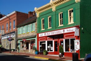
Downtown Luray is charming, if not understated, and the downtownluray.com website offers a list of places to eat, stay, and play.
If you’re looking for a hotel, staying at a locally-owned property will greatly help the local community.
Luray Caverns is a must-see.
These stunning underground caves are the largest on the East Coast and feature awe-inspiring stalactites and stalagmites.
The Great Stalacpipe Organ, which produces music by striking the formations, is a highlight and is also referred to as the “World’s Largest Musical Instrument.”
Above ground at the Luray Caverns, you can explore a hedge maze, Shenandoah Heritage Village, the Car & Carriage Caravan Museum, and Toy Town Junction, just to name a few.
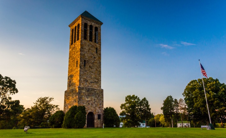
Another highlight near the caverns is another type of music, this time from the Luray Carillon Singing Tower.
The Carillion of nearly 50 bells sends the sweet sound of music through the valley during regularly scheduled free performances.
Fans of the “Dukes of Hazzard” will enjoy a visit to Cooter’s in Luray, which features a museum, gift shop, and restaurant, while occasionally hosting special events with cast members from the show.
You’d have to go to much bigger cities like Nashville and Pigeon Forge to see the other franchises, making this a more intimate experience.
For outdoor enthusiasts, Shenandoah River Outfitters offers canoeing, kayaking, tubing, and rafting trips on the scenic Shenandoah River.
Places to Avoid in Luray
The town is small and easy to get around, but you don’t need to worry about dangerous neighborhoods.
Keep in mind the long, narrow nature of Shenandoah National Park.
The valley parallels that landscape for almost 100 miles, and there are several towns to consider that will get you easy access to the park.
For example, if you want to take the Blue Ridge Parkway, that road is about 70 miles from Luray.
Waynesboro or Staunton would be closer communities.
Luray Zoo – A Rescue Zoo is home to a variety of exotic animals, many of which have been rescued.
It offers an educational experience with up-close animal encounters.
While there are reports the zoo is not accredited, and many complaints fill the reviews, I’d recommend researching it before deciding if it’s somewhere you want to visit.
Safety Tips for Traveling to Luray
- Luray has a local police department. You can follow them on Facebook @LurayPD. For specific safety questions, you can DM them on Facebook or call (540) 743-5343.
- Page County uses the CodeRED system to send out emergency notifications. In just a few seconds, you can sign up for these alerts, which cover severe weather and public safety hazards. You can also follow @PAGEECC on Facebook for a general overview of safety information.
- Download the National Park Service App to get the best information about Shenandoah National Park and daily updates about safety risks, trail closures, and weather impacts. You can also check the fire risk through the Virginia Department of Forestry.
- Between March 1 and November 30, a day-use permit is required to hike Old Rag in Shenandoah National Park. You’ll need to purchase those in advance as you can’t buy them at the trailhead or in the park. Half of the tickets are released 30 days in advance, while the remaining are available five days before the day of a hike.
- The national park has a number of trail blazes. Those are important to keep an eye on, as it’s the best information you can give emergency crews if you need to be rescued.
- Carry bear spray with you at all times, but only use it if a black bear attack is imminent. While there’s some debate about whether bear spray is needed for black bears vs grizzly bears, you shouldn’t rely on it as your only defense against a bear. Keep talking while you’re on a trail, and slowly back away from any bear sighting, speaking in a clear, firm voice. Most people just say, “Hey, Bear! Woah, Bear!”
- If you plan on riding the river, be honest with your tour guide about your experience level. They can tailor the activity to meet your skill level while still providing an invigorating adventure. Follow all the rules for safety vests and check the water levels and water quality through the USGS and Friends of the Shenandoah River websites.
- Luray Caverns is a comfortable 54°F year-round, but the humidity will make it feel like it’s in the 60s. The path is wheelchair friendly, but a few elevated grades in the cave might require someone to help push it along.
- Since this is an Appalachian Trail town, you might see hitchhikers on the roads. While the laws are varied, you are under no obligation to pick up a hitchhiker.
- Those hiking the Appalachian Trail will find a hostel in Luray, and you can look up a shuttle service for the hour-long trip to the town. Jenkins Shuttle Service, Yellow Cab of Luray and Shenandoah River Adventures are three that offer shuttles to thru hikers.
So... How Safe Is Luray Really?
Luray is a safe place to visit, and crime data backs that up.
Over the past 25 years, the city hasn’t seen more than 14 violent crimes in a year, and that “high” number only happened once.
Before 2018, the highest number of crimes in a year was nine.
Keep in mind that’s the number of crimes in the city considering the population and the hundreds of thousands of people who visit each year.
Thefts are technically 36% higher than the national average, but when dealing with such a small town, that breaks down to less than 100 thefts a year.
The biggest category of theft is “other,” which means things like stolen supplies from a construction site or thefts from yards.
About one-quarter of theft is shoplifting.
Beyond that, there are the wilderness and outdoor risks that largely depend on your knowledge and actions.
Hopefully, in this article, we’ve helped you prepare for that so you can enjoy the many things you can do in Luray, Virginia.
How Does Luray Compare?
| City | Safety Index |
|---|---|
| Luray | 81 |
| San Diego | 67 |
| Miami | 55 |
| Honolulu | 65 |
| Chicago | 65 |
| Dallas | 64 |
| Memphis | 54 |
| Melbourne (Australia) | 80 |
| Montreal (Canada) | 81 |
| Sydney (Australia) | 80 |
| Santiago de Chile (Chile) | 71 |
| Vienna (Austria) | 88 |
| Hong Kong (China) | 70 |
Useful Information

Visas
All international visitors need either a visa defining the purpose of the trip (tourist, work, school, etc.) or a visa waiver. Start the process using the Visa Wizard module on the U.S. State Department website. Also, your passport must be valid for at least six months after your trip, or you’ll need to apply for a new one.

Currency
Only the U.S. Dollar (USD) is accepted in the United States. International airports usually have a currency exchange desk on site, while regional airports won’t. Your home bank offers the lowest fees. For those using credit cards, check to see if there’s a foreign transaction fee.

Weather
You’ll get a nice mix of all four seasons in Luray, but plan for the cooler temperatures in the cavern and in the mountains. Bring several layers of clothing with an insulated outer layer. Hiking boots and trekking poles will be helpful on the trails. Bug spray is a must.

Airports
The closest commercial airports to Luray, Virginia, are Shenandoah Valley Regional Airport (SHD), about 50 miles away, and Charlottesville-Albemarle Airport (CHO), approximately 60 miles away.

Travel Insurance
Comprehensive travel insurance offers the most expansive coverage, including personal items, health emergencies, and travel delay or cancelation costs. Depending on what you plan to do while you’re here, consider adventure insurance for the more high-risk activities.
Luray Weather Averages (Temperatures)
Average High/Low Temperature
| Temperature / Month | Jan | Feb | Mar | Apr | May | Jun | Jul | Aug | Sep | Oct | Nov | Dec |
|---|---|---|---|---|---|---|---|---|---|---|---|---|
| High °C | 7 | 9 | 14 | 20 | 24 | 29 | 31 | 30 | 26 | 21 | 15 | 9 |
| Low °C | -6 | -4 | 1 | 5 | 10 | 14 | 16 | 16 | 12 | 6 | 1 | -3 |
| High °F | 45 | 48 | 57 | 68 | 75 | 84 | 88 | 86 | 79 | 70 | 59 | 48 |
| Low °F | 21 | 25 | 34 | 41 | 50 | 57 | 61 | 61 | 54 | 43 | 34 | 27 |
Virginia - Safety by City
| City | Safety Index |
|---|---|
| Alexandria | 47 |
| Arlington | 77 |
| Blacksburg | 79 |
| Charlottesville | 68 |
| Chesapeake | 69 |
| Chincoteague Island | 77 |
| Danville | 76 |
| Hampton | 67 |
| Leesburg | 72 |
| Luray | 81 |
| Lynchburg | 77 |
| Newport News | 68 |
| Norfolk | 43 |
| Petersburg | 52 |
| Portsmouth | 51 |
| Richmond | 60 |
| Roanoke | 47 |
| Staunton | 77 |
| Virginia Beach | 77 |
| Waynesboro | 78 |
| Williamsburg | 78 |
| Yorktown | 82 |
