 Utah : Safety by City
- Bicknell
- Brigham City
- Bryce Canyon City
- Cedar City
- Green River
- Hurricane
- Kamas
- Kanab
- Layton
- Lehi
- Moab
- Ogden
- Orem
- Panguitch
- Park City
- Provo
- Salt Lake City
- Sandy
- St. George
- Vernal
- West Jordan
- West Valley City
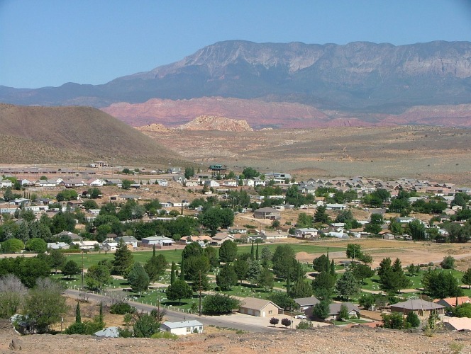
The first thing to know about Hurricane, Utah, is that you’re probably saying it wrong.
HER-ah-kun is a city of 20,000 people between St. George and Springdale on the way to Zion National Park.
Despite its name, there isn’t a hurricane threat here.
However, the windy nature of the desert led to a settler bracing during a high wind event and saying, “Well, that’s a hurricane.”
He named the location Hurricane Hill.
The name stuck, and the pronunciation was adapted to the English accent of the time.
Like many communities in Southern Utah, settlers stuck close to the Virgin River.
The Indigenous people of the area, the Paiute Indians, called this area “Timpoweap,” which means Rock Canyon.
As Zion National Park grows in popularity, Hurricane is getting more tourists and quickly becoming an overflow for crowds who can’t find a place to stay in Springdale, which is right outside the park.
Those coming from Nevada to get to the North Rim of the Grand Canyon or Glen Canyon National Recreation Area also pass through Hurricane.
I expect the city to keep growing in amenities and attractions as the years go on since the popularity of recreation is skyrocketing in the 2020s.
Warnings & Dangers in Hurricane

OVERALL RISK: LOW
There's a low risk in Hurricane and you should have no concerns about driving through, stopping for a few hours, or spending the night.

TRANSPORT & TAXIS RISK: LOW
The St. George Sun Tran bus system doesn't go as far as Hurricane. Taxis and rideshares are available, but it's going to add up if you're trying to get to Zion National Park. Having a rental car is the best option. For the most efficient use of taxis or rideshares, get a ride to Springdale and use the Zion shuttle to get around the park.

PICKPOCKETS RISK: LOW
Twelve pickpockets or purse snatchings were reported between 2018 and 2022, with purse snatchings making up 11 of those. That averages about 2-3 a year, which is a low risk.

NATURAL DISASTERS RISK: MEDIUM
Hurricane Fault runs from the Grand Canyon, past Hurricane, and up to Cedar City. This is the most dangerous fault line in the region, capable of producing major earthquakes. This area also gets extreme heat in the summer. Monsoon storms capable of producing flash flooding are a summer risk. Dangerous lightning accompanying storms can spark wildfires. Winter can bring snow or ice to various elevations, making travel treacherous. The medium risk means you must check the forecast, road, and park conditions daily.

MUGGING RISK: LOW
Going as far back as 2010, the city hasn't had more than two robberies in a year. Four years had just one robbery, and one year had none. The risk is low but never low enough to let your guard down.

TERRORISM RISK: LOW
This is a low risk as the area is rather remote and surrounded by federal lands. You should still notify the police if you see anything suspicious.

SCAMS RISK: LOW
Check local law enforcement social media sites for the latest scams. Since this is a popular retirement area, senior scams tend to be more likely. The risk is low, but stay informed to keep it that way.

WOMEN TRAVELERS RISK: LOW
Nothing in the crime data or recent news reports suggests women would be at a greater risk than anyone else. It's best to travel with at least two friends, especially if you're in remote areas.

TAP WATER RISK: LOW
The U.S. has strict standards for tap water per the Safe Water Drinking Act. Communities are required to provide a Water Quality Report (Consumer Confidence Report) once a year by July 1. The 2023 Water Quality Report shows two violations due to reporting errors in drinking water disinfection byproducts. While this violation didn't pose a health risk, it's still against the law requirements. The risk is low when using tap water, but that doesn't extend to river water or other water sources in nature.
Safest Places to Visit in Hurricane
The Hurricane City website has a tourism section, with a list of things to do in the city and the surrounding area.
If you want information about Zion National Park, use nps.gov/zion.
Another great website to use is GreaterZion.com.
The history of this region is fascinating, and you can learn more about it at the Hurricane Pioneer Museum.
You can also visit the Hurricane Canal, Bradshaw House (the first home in Hurricane), and the Hinton Home (early pioneers).
The vast expanse of wilderness here is primarily public land, which makes it a great place to explore legally.
However, it can be confusing to find out where one place ends and another begins.
Most of the land west of Zion and around Hurricane is Bureau of Land Management (BLM) land.
Many trails in this area, like Mollies Nipple and Hurricane Cliffs, were designed for either ATV or mountain biking.
Before you start a trail, please review the best ways to travel it.
The different land management is important to know because national parks won’t allow ATVs, which BLM lands will.
Sand Hollow State Park is just south of Hurricane, with more ATV trails and an opportunity to go boating or kayaking.
Mad Moose Rentals is a great place to look for guided tours or gear rentals.
Quail Creek State Park is nearby as well, with similar amenities and a Mad Moose location on-site in addition to DIG Paddlesports.
While it’s impossible to list ALL the trails in this region, use a website like All Trails to get full details and honest reviews of each one.
It can save you a lot of heartache and frustration.
For example, some people say the Three Falls Trail doesn’t have three falls and private property limits access in some parts.
Several businesses offering sky driving or helicopter tours are near Hurricane.
Skydive Zion is on the south side of the city and Zion Helicopters is to the east in Virgin.
Those heading to Zion National Park should know there are two entrances.
First, the South Entrance is in Springdale, 23 miles from Hurricane.
Arrive before 8 am if you want any hope of not being stuck in massive traffic, especially from March through October.
Second, the Kolob Canyon entrance is 22 miles north, and there will be very little traffic.
However, the views are amazing, and the smaller crowds allow for a more relaxing experience.
If you plan on camping or backpacking overnight in Zion, you need a permit.
Places to Avoid in Hurricane
You don’t need to avoid any place in Hurricane from a crime perspective.
Basic personal safety steps will keep the risk low.
While it sounds obvious, you should avoid any flooded roads or going to the river if flooding is imminent or happening.
Look for flood advisories, watches, or warnings through the local National Weather Service.
One thing I want to harp on for a moment is to avoid reading misleading information online, especially if it lacks official sources.
For what it’s worth, all of our data comes from the FBI’s official NIBRS crime data.
While researching, I found an article that labeled Hurricane “Top 5 Worst Cities in Utah,” written in August 2023.
It cited a “whopping 12.4%” poverty rate.
It also claimed robberies were “one of the most prolific crimes.”
All of that is wrong and misleading.
First, the poverty rate, as of the 2020 census, was 10.5% in Hurricane.
That’s a full one percent lower than the average national poverty rate in 2020.
Robberies?
Since 2017, there have been two robberies in TOTAL.
In addition, I searched the Facebook page of the police department for the word “Robbery,” and the most recent post was in 2017.
As a data journalist, it’s frustrating to see such wrong and unsourced information showing up in search results.
You can trust our data here or at least know where the source of the information comes from.
Safety Tips for Traveling to Hurricane
- Hurricane has a local police department. You can follow them on Facebook @HurricaneCityUTPD or Instagram @hurricanecitypd. The phone number is (435) 635-9663, and the email is communitypolice@hurricane.utah.gov if you have specific safety questions.
- Sign up for emergency notifications through Washington County Utah Citizen Alert. You can get emails, phone calls, or text messages. The alerts will cover public safety hazards, severe weather, winter weather, and major road closures.
- Since mobile service won’t always be available in this remote area, lock your radio into Station 104.5 FM to get emergency information. You can also get a NOAA weather radio that can’t be impacted by power outages or disconnected cell service.
- The Virgin River is known for having toxic cyanobacteria and cyanotoxin blooms in the water. Drinking the water or ingesting it in any way, like splashing water on your face, can make you very sick. It is especially lethal to pets. Visit the Utah Department of Environmental Quality for updated testing information. Assume the water is too dangerous to use unless you learn otherwise.
- The police department posts a weekly summary of criminal activity and police calls on Facebook. This will include non-criminal things like stray dogs or stranded motorists, but it also can show if there’s a trend in car break-ins or a sudden “prolific crime” of robbery happening. (Yes, I’m still stuck on the fake information about the robbery rate.)
- Download the Utah Hunting and Fishing app through the Division of Wildlife Resources if you want to fish while you are here. Anyone 12 or older needs a license. You can purchase the license online, but be sure to carry proof of it with you while fishing.
- Download the National Park Service app so that you can get information about Zion or any of the other Mighty 5 you might plan to visit while you’re here. This app offers offline maps, but be sure to download them when you have a good internet connection.
- Due to increased crowds at Zion National Park, a permit is required to hike Angels Landing. Hikers can go as far as Scout Lookout without having a permit, but proof will be required. Permits are issued by lottery only and are required year-round.
- Even if you are just driving through Zion on Mt. Carmel Highway, you must have a Park Pass or an America the Beautiful Interagency Pass. Purchase that ahead of time so that you don’t slow down traffic even more (and tell everyone you see to do the same – traffic is crazy here!).
- Pack an emergency kit in your car, as a breakdown on the side of the road or a remote area could lead to hours or days going by before you can be rescued. The emergency management website for the city, county, or state can provide a checklist of things to bring.
- BONUS: As of 2024, there is a plan to redo the South Entrance to Zion National Park. The overall goal is to better accommodate traffic, but in the meantime, it will be pure chaos trying to get into the park. Check the park conditions before you go, and consider visiting Kolob Canyon, which is a part of the park that will not be impacted by road construction.
So... How Safe Is Hurricane Really?
Hurricane’s violent crime rate is just 2.5% higher than the state average and 41% lower than the national average.
However, that rate only includes the population and raw crime data calculations.
It doesn’t account for the millions of people who visit or drive through each year.
Just 30% of the crimes that happen involve strangers, and two-thirds happen in private homes, which lowers the risk even more.
Thefts are about 20% lower than the national average.
30% of all thefts are shoplifting, and another 16% are car break-ins.
However, most car break-ins happen because people leave vehicles unlocked, keys inside the vehicle, or valuables inside the vehicle.
The biggest risks here are directly tied to a visitor’s attention to safety steps and education about hazards.
When visiting this area, expect traffic.
You can’t control how many people visit, but you can control your road rage.
You can check if you’re paying attention to the road or driving while distracted.
You control your speed.
With all the risks in the national park, only in very limited instances will rangers stop you from doing risky behavior.
For example, if you’re scared of heights and climbing Angels Landing, nobody is going to say, “Are you sure?”
However, the Narrows will be closed when water exceeds a certain level.
Common sense, wilderness training, and situational awareness go a long way in enjoying everything Hurricane and Southern Utah have to offer.
How Does Hurricane Compare?
| City | Safety Index |
|---|---|
| Hurricane | 83 |
| St. Louis | 58 |
| Los Angeles | 56 |
| Oakland | 57 |
| New Orleans | 57 |
| Baltimore | 56 |
| Boston | 67 |
| Sofia (Bulgaria) | 73 |
| Siem Reap (Cambodia) | 63 |
| Phnom Penh (Cambodia) | 61 |
| Niagara Falls (Canada) | 87 |
| Calgary (Canada) | 82 |
| Buenos Aires (Argentina) | 60 |
Useful Information

Visas
All international visitors need either a visa defining the purpose of the trip (tourist, work, school, etc.) or a visa waiver. Start the process using the Visa Wizard module on the U.S. State Department website. You’ll quickly find out which one you need. Also, keep in mind that your passport must be valid for at least six months after our trip, or you’ll need to apply for a new one.

Currency
Only the U.S. Dollar (USD) is accepted in the United States. International airports usually have a currency exchange desk on site, while regional airports won’t. Your home bank offers the lowest fees. For those using credit cards, check to see if there’s a foreign transaction fee before you start racking up charges. Don't wait until you get to Hurricane to get cash. Cash is accepted to purchase a Zion National Park Pass, but credit cards are preferred.

Weather
Being in the Southern Utah desert doesn't mean it's hot all the time, but it does mean it's a place of extremes. Winters get below freezing at night, with highs in the 50s, and summer days easily get near or above triple digits. Wear comfortable outdoor clothing that can get wet, muddy, or dusty. Sturdy shoes with good grip are a must if you're going hiking. Sunscreen is needed year-round.

Airports
St. George Regional Airport (SGU) is about 30 minutes from Hurricane. If you're flying out of Las Vegas, plan for two and a half hours on the road. Also, Nevada is in the Pacific Time Zone, while Utah is in the Mountain Time Zone. That means when you're heading to Hurricane, you'll gain an hour but lose an hour on the way back.

Travel Insurance
Comprehensive insurance offers the best protection and peace of mind. If you're planning on doing extreme adventures, like Angels Landing or The Narrows, consider adventure insurance, which can help recoup the costs of a rescue or air flight to a hospital.
Hurricane Weather Averages (Temperatures)
Average High/Low Temperature
| Temperature / Month | Jan | Feb | Mar | Apr | May | Jun | Jul | Aug | Sep | Oct | Nov | Dec |
|---|---|---|---|---|---|---|---|---|---|---|---|---|
| High °C | 12 | 15 | 19 | 24 | 29 | 35 | 38 | 36 | 32 | 25 | 17 | 12 |
| Low °C | -2 | 1 | 4 | 6 | 11 | 16 | 19 | 19 | 14 | 8 | 1 | -3 |
| High °F | 54 | 59 | 66 | 75 | 84 | 95 | 100 | 97 | 90 | 77 | 63 | 54 |
| Low °F | 28 | 34 | 39 | 43 | 52 | 61 | 66 | 66 | 57 | 46 | 34 | 27 |
Utah - Safety by City
| City | Safety Index |
|---|---|
| Bicknell | 81 |
| Brigham City | 82 |
| Bryce Canyon City | 82 |
| Cedar City | 86 |
| Green River | 83 |
| Hurricane | 83 |
| Kamas | 79 |
| Kanab | 79 |
| Layton | 81 |
| Lehi | 74 |
| Moab | 84 |
| Ogden | 72 |
| Orem | 82 |
| Panguitch | 78 |
| Park City | 78 |
| Provo | 94 |
| Salt Lake City | 55 |
| Sandy | 93 |
| St. George | 94 |
| Vernal | 83 |
| West Jordan | 94 |
| West Valley City | 65 |