 Washington : Safety by City
- Anacortes
- Bainbridge Island
- Bellevue
- Diablo
- Forks
- Gig Harbor
- Kennewick
- Kent
- Kettle Falls
- Longview
- Mercer Island
- Moses Lake
- Neah Bay
- Ocean Shores
- Olympia
- Port Angeles
- Port Townsend
- Poulsbo
- Pullman
- Quinault
- Renton
- San Juan Islands
- Seabrook
- Seattle
- Sequim
- Snoqualmie
- Spokane
- Spokane Valley
- Tacoma
- Walla Walla
- Wenatchee
- Westport
- Yakima
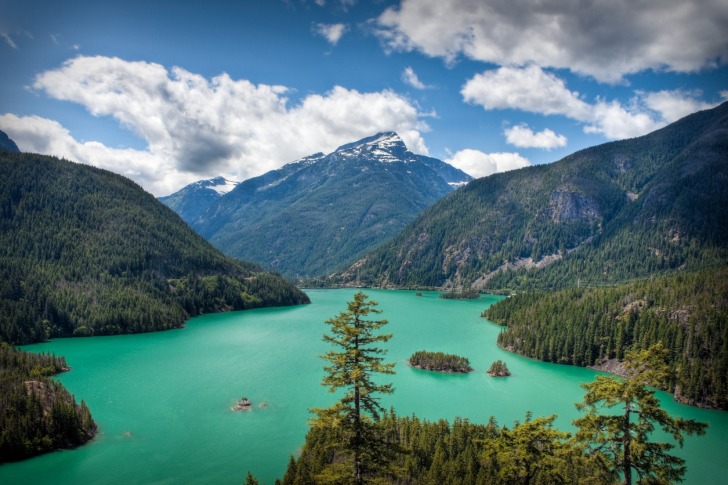
Diablo, Washington, is more of a place than a city or town in the North Cascades of Washington.
It sits about 90 miles east of Bellingham.
The area is centered around Diablo Lake, a reservoir created by the Diablo Dam, which was completed in 1930 as part of Seattle City Light’s Skagit River Hydroelectric Project.
The turquoise hue of the lake, caused by glacial flour suspended in the water, is one of its most striking features.
The town of Diablo is a gateway to the North Cascades, often referred to as the “American Alps” for its rugged, snow-capped peaks and deep valleys.
Visitors can explore the park through a network of hiking trails that range from easy walks to challenging backcountry routes.
Popular activities include kayaking on the lake, fishing, and camping.
The North Cascades Highway (State Route 20) offers scenic drives with breathtaking views and access to numerous trailheads.
Diablo is in the North Cascades National Park Complex, which includes three National Park Service properties.
Warnings & Dangers in Diablo

OVERALL RISK: LOW
Crime will be the least of your concerns here, but there are enough wilderness, wildlife, water, and weather risks to keep you busy. Responsible stewardship and self-preparation for the elements are critical to keeping the risk low.

TRANSPORT & TAXIS RISK: LOW
You'll need a vehicle to get this far outside of Bellingham and to the remote section of Skagit County. You might find tour companies that will take you to certain stops on Route 20. Check the Skagit Transit website for the most recent routes. However, a rental car that is four-wheel drive or at least all-wheel drive is your best option.

PICKPOCKETS RISK: LOW
In this area, you should be more concerned about a bear taking your stuff than another person. Of course, leave valuables at home and pack only what you need, but include bear-proof containers and the proper outdoor gear to keep this risk low.

NATURAL DISASTERS RISK: MEDIUM
Diablo faces natural disaster risks primarily from wildfires and landslides due to its mountainous terrain and dense forests. The region's heavy snowfall also increases the risk of avalanches in winter, but access to the public is limited during that time. Additionally, the area is seismically active, making it vulnerable to earthquakes that could impact infrastructure and safety. All in all, it's a medium risk.

MUGGING RISK: LOW
This is another low risk, as there are places around Diable Lake and in the North Cascades where you'll be the only person for miles. Don't let your guard down, but you certainly have bigger things to worry about than getting mugged.

TERRORISM RISK: LOW
This is an extremely low risk, as the area is so remote and rugged. The presence of a dam will always raise risks, but plenty of security protects the dam at the state and federal levels.

SCAMS RISK: LOW
The police department and local sheriff’s office will post the latest scams on social media. Check with park rangers when you arrive to see if there are any reports of fraudulent activity, but again, crimes aren't the biggest concerns here. This is a low risk.

WOMEN TRAVELERS RISK: LOW
Women have the same risk as anyone else, which includes wilderness survival skills, technology to help track them down if they get lost, and at least a group of three people to hike with.

TAP WATER RISK: LOW
The U.S. has strict standards for tap water per the Safe Water Drinking Act. Communities are required to provide a Water Quality Report (Consumer Confidence Report) once a year by July 1. Any water that comes from a tap should be safe for consumption, but the National Park Service will post information about water quality in springs or containers along the trails (where available). The risk is low, but you should also be prepared to treat your own drinking water in the wilderness if it comes from a lake, spring, or river.
Safest Places to Visit in Diablo
The Visit Bellingham/Whatcom County website is one website that covers things to do in this region, but it’s not hyper-focused on Diablo Lake.
You can also use VisitSkagitValley.com for Diable Lake information, but it covers the surrounding region as well.
Since public lands surround Diablo Lake, I wanted to list them to help with your internet research.
- Ross Lake National Recreation Area (where Diablo Lake is located)
- North Cascades National Park (north and south of the lake)
- Lake Chelan National Recreation Area (south of Diablo Lako)
- Mount Baker Wilderness (U.S. Forest Service Property)
- Rockport State Park (Washington State Parks)
One of the best ways to see this region is by taking the Cascade Loop, which runs 440 miles through stunning landscapes.
Diablo is on the northern edge of this loop, 90 miles east of Bellingham.
Diablo and Diable Lake are about as centrally located in the “middle of nowhere” as possible in this part of Washington.
However, it’s also a great pivot point for several of the best places to visit.
When approaching Diablo from the west, stop at the Visitor Center in Newhalem.
Then, plan a stop at the Gorge Creek Falls, dropping nearly 250 feet to Gorge Lake.
You’ll leave Highway 20 to head north on Diablo Dam Road, which leads to the trailhead for Diablo Lake.
This trail is a 7.6-mile roundtrip with a 1,400-foot elevation gain.
It’s a moderate hike with rewarding views at the top.
If you aren’t up for a long hike, continue on Highway 20 after seeing the dam and head to Diablo Lake Vista Point for just as great views.
For a longer hiker, look up Sourdough Mountain’s tough 10.4-mile roundtrip hike, which gains a whopping 4,900 feet in elevation.
If you’re looking for a campsite, check out the Buster Brown option on the north shore of Diablo Lake.
Places to Avoid in Diablo
As noted above, Highway 20 closes annually due to excessive amounts of snow.
Expect closures to start as early as October and run through late May.
The Washington State Department of Transportation (WSDOT) will have updates on the road status.
The closures run from west of Mazama to east of Diablo.
In most winters, hiking, skiing, and snowmobiling are allowed on the closed-to-vehicles highway.
You should also check the road conditions on real-time WSDOT maps in the summer, as wildfire activity can lead to closures.
It’s wise to study the difference between a designated wilderness area and a national park or national recreation area.
Wilderness areas don’t have roads beyond the main entrance points.
Hikes can be days long, and you will have no resources along the way beyond what you bring with you.
Safety Tips for Traveling to Diablo
- Follow the Whatcom County Sheriff’s Office on Facebook @WhatcomSheriff to get updated on safety and activities. You can also call (360) 778-6600 if you have specific safety questions.
- Sign up for alerts through WSDOT to get road information updates throughout your trip. Search the website for “Real Time Alerts” to find the list of closures and warnings.
- Download the National Park Service app and download maps that can be used offline for the North Cascades National Park Complex. Be sure you do this when you have a strong internet connection.
- Bring a NOAA weather radio with you into the wilderness, as mobile service will be limited to non-existent.
- Snow can be present in the higher elevations into August, and you should keep this in mind for the delays it will take to navigate snow and ice on long hikes. When snow covers a trail, you won’t have any blazes or trail markers to help you find your way.
- Do not trust your GPS for accurate directions. Bring paper maps, ideally with waterproof coatings, and use those to navigate instead of any kind of tracking device.
- Paddling is allowed on Diablo Lake, but swimming isn’t a good idea since the water rarely gets above 50°F. Even on a warm summer day, the water can cause hypothermia or cold water shock.
- Bear spray is allowed in this national park complex but should only be used if a bear attack is imminent. There are plenty of other safety tips to let bears know you’re in the area but don’t pose a threat to them. Consider the scent of any items you bring, from food to hygiene products, and keep them in bear-proof containers.
- Stay at least 100 yards away from bears and 25 yards from moose, elk, mountain goats, and coyotes. The NPS website has a great list of ways to avoid interactions with each animal, as well as tactics to prevent an attack if you get too close.
- If you plan to stay overnight in the wilderness around Diablo Lake, you’ll need a wilderness permit from the National Park Service. The person who signed up for the permit must pick it up in person. Be prepared to answer questions about where you plan to go and when you’ll be back. This is for your safety if you go missing.
So... How Safe Is Diablo Really?
Crime data isn’t available specifically for Diablo for several reasons.
First, it’s an unincorporated community in Whatcom County.
Using the county crime data wouldn’t be a good option since 231,000 people live there, but less than 1,000 are in Diablo.
However, in the spirit of transparency, I looked up the violent crime rate in the county.
It’s 83% lower than the national average.
Theft rates are 84% lower.
Then there’s the issue of Diablo and the lake being on National Park Service property, and the federal agency doesn’t release crime data like law enforcement agencies do.
This circles back around to the natural elements, which are the most risky part of a trip to Diablo.
While some parks like Yosemite or Zion might be packed with people and give a “safety in numbers” vibe, Diablo and the North Cascades are about as wild as a national park can get.
It’s more like visiting an Alaska National Park than one of Utah’s Mighty (crowded) Five.
If you’re prepared for the rugged terrain, you’re in for a mesmerizing natural treat.
This area is just jaw-dropping at every turn.
How Does Diablo Compare?
| City | Safety Index |
|---|---|
| Diablo | 78 |
| Dallas | 64 |
| Memphis | 54 |
| Orlando | 64 |
| Las Vegas | 62 |
| San Francisco | 61 |
| Philadelphia | 60 |
| Vienna (Austria) | 88 |
| Hong Kong (China) | 70 |
| Manama (Bahrain) | 54 |
| Tianjin (China) | 67 |
| Brussels (Belgium) | 60 |
| Shanghai (China) | 66 |
Useful Information

Visas
All international visitors need either a visa defining the purpose of the trip (tourist, work, school, etc.) or a visa waiver. Start the process using the Visa Wizard module on the U.S. State Department website. Also, your passport must be valid for at least six months after your trip, or you’ll need to apply for a new one.

Currency
Only the U.S. Dollar (USD) is accepted in the United States. International airports usually have a currency exchange desk on site, while regional airports won’t. Your home bank offers the lowest fees. For those using credit cards, check to see if there’s a foreign transaction fee. Credit cards, not debit cards, offer the best fraud protection.

Weather
The only consistent part of the weather in the North Cascades is the inconsistency. Summers can get into the 80s (F) for highs, but with so many different elevations, temperatures can drop quickly, and storms can cause powerful winds and dangerous lightning. Bring layers of clothing, even in the summer. Hiking boots with crampons or microspikes are needed year-round, especially if you plan to visit the higher elevations.

Airports
Diablo is about two hours from Bellingham International Airport, with Alaska, Allegiant, Southwest and San Juan Airlines serving the airport. The larger Seattle-Tacoma International Airport is about three hours away.

Travel Insurance
Travel insurance protects the cost of baggage loss/theft, delays, cancelations, and emergency health issues. Rental car insurance should include roadside assistance and uninsured motorist coverage. Comprehensive insurance offers the best peace of mind.
Diablo Weather Averages (Temperatures)
Average High/Low Temperature
| Temperature / Month | Jan | Feb | Mar | Apr | May | Jun | Jul | Aug | Sep | Oct | Nov | Dec |
|---|---|---|---|---|---|---|---|---|---|---|---|---|
| High °C | 3 | 6 | 9 | 13 | 18 | 21 | 25 | 25 | 21 | 14 | 6 | 3 |
| Low °C | -2 | -2 | 1 | 2 | 6 | 9 | 11 | 11 | 8 | 4 | 1 | -2 |
| High °F | 37 | 43 | 48 | 55 | 64 | 70 | 77 | 77 | 70 | 57 | 43 | 37 |
| Low °F | 28 | 28 | 34 | 36 | 43 | 48 | 52 | 52 | 46 | 39 | 34 | 28 |
Washington - Safety by City
| City | Safety Index |
|---|---|
| Anacortes | 82 |
| Bainbridge Island | 85 |
| Bellevue | 84 |
| Diablo | 78 |
| Forks | 85 |
| Gig Harbor | 75 |
| Kennewick | 40 |
| Kent | 42 |
| Kettle Falls | 78 |
| Longview | 82 |
| Mercer Island | 82 |
| Moses Lake | 46 |
| Neah Bay | 77 |
| Ocean Shores | 79 |
| Olympia | 57 |
| Port Angeles | 72 |
| Port Townsend | 81 |
| Poulsbo | 79 |
| Pullman | 79 |
| Quinault | 82 |
| Renton | 70 |
| San Juan Islands | 83 |
| Seabrook | 78 |
| Seattle | 55 |
| Sequim | 77 |
| Snoqualmie | 78 |
| Spokane | 74 |
| Spokane Valley | 62 |
| Tacoma | 38 |
| Walla Walla | 72 |
| Wenatchee | 80 |
| Westport | 78 |
| Yakima | 62 |
