 Utah : Safety by City
- Bicknell
- Brigham City
- Bryce Canyon City
- Cedar City
- Green River
- Hurricane
- Kamas
- Kanab
- Layton
- Lehi
- Moab
- Ogden
- Orem
- Panguitch
- Park City
- Provo
- Salt Lake City
- Sandy
- St. George
- Vernal
- West Jordan
- West Valley City
Cedar City, Utah, is a fast-growing city of 20,000 people in Southern Utah, thanks to its convenient location off I-15 and proximity to some of the best national parks in the country.
Geology tells the story across the unique rock formations, but within those canyons, you’ll find prehistoric petroglyphs and even some dinosaur footprints.
Modern history dates back to 1851 when Mormon settlers arrived to mine for iron and coal.
The mining industry declined, and agricultural prospects weren’t helping the town grow, so in the end, it was tourism that helped give Cedar City its current-day boost.
In fact, between 2020 and 2023, the city grew by 13%, with a population near 40,000.
Cedar City has several nicknames, like Festival City USA, the Gateway to the Parks, and Iron City.
While the latter is clearly from its mining day, Festival City comes from major events, like the annual Utah Shakespearean Festival.
The Gateway to the Parks means its proximity to Zion, Bryce Canyon, and Capitol Reef National Parks, with Arches and Canyonlands a little further east.
It’s also close to the ski destination of Brian Head and Cedar Breaks National Monument.
Visitors also have the vast expanse of Dixie National Forest as the backyard.
Whether you’re a history buff, a culture vulture, or an outdoor enthusiast, Cedar City has something special to offer.
Its friendly vibe and stunning surroundings make it a destination you’ll want to return to again and again.
Maybe you’ll even be among the 13% of people who decide to move here!
Warnings & Dangers in Cedar City

OVERALL RISK: LOW
There's a low risk in Cedar City and something to do for all generations and interests. Don't let the remote location fool you.

TRANSPORT & TAXIS RISK: LOW
CATS is the public transportation system in Cedar City, with a surprising number of stops for a rather small city. Taxis and rideshares are easy to find. Rental cars are the best way to explore. All options have a low risk.

PICKPOCKETS RISK: LOW
While no pickpockets have been reported in the past five years, 29 purse snatchings have. That's about six per year, and while the risk is low, it's still something to consider when packing a purse to carry on your trip.

NATURAL DISASTERS RISK: MEDIUM
This is a medium risk due to the number of challenges the city sees each year. To start with, the Hurricane Fault runs north and south from the Grand Canyon to Cedar City, which can cause major earthquakes. With an average of 110 inches of snow each year, winters can be challenging, though the reward of great skiing is worth it. Summer monsoons cause flash flooding, dangerous thunderstorms, and damaging winds.

MUGGING RISK: LOW
Over the past five years, there have been 11 robberies in Cedar City. Not one of them was a mugging. The risk is low, but don't let that information cause you to let your guard down.

TERRORISM RISK: LOW
This is a low risk and one way the remote location benefits the community. With public land on all sides, this isn't a place where international terrorists would even think of targeting.

SCAMS RISK: LOW
Check local law enforcement social media sites for the latest scams. The local Better Business Bureau office and the state Attorney General’s office will have common scam tactics and protection advice. Most scams target residents or the elderly, but you should know the short-term housing rules and avoid getting roped into paying for a fake listing. The risk is low, but being consumer-conscious helps keep it that way.

WOMEN TRAVELERS RISK: LOW
This is another low risk, and there is no reason to believe women would be at a higher risk. Of course, you still need wilderness and weather emergency training and should know not to walk around after dark alone or go into the wilderness solo.

TAP WATER RISK: LOW
The U.S. has strict standards for tap water per the Safe Water Drinking Act. Communities are required to provide a Water Quality Report (Consumer Confidence Report) once a year by July 1. The city hasn't posted a water quality report since 2022, and in that year, five violations were found related to coliform bacteria in tests. The issue was fixed, and no details of additional violations have been reported since. The risk is low, but check the utility website before you visit to see the latest water quality report.
Safest Places to Visit in Cedar City
VisitCedarCity.com is the tourism website for Cedar City and Bryan Head.
You can download a free visitor’s guide without having to give personal information, but they don’t make it look that easy.
Be sure to click on the word HERE above the section where you’re asked to fill out the form.
There is an additional website, visitbrianhead.org if you want to know more about that city and ski area.
Downtown Cedar City mixes modern amenities with historical significance, with a flair for art thrown in.
Enjoy the murals while you explore local shops and restaurants.
Don’t miss the Old Rock Church, built in the 1930s from locally sourced materials.
The Frontier Homestead State Park Museum showcases the pioneering spirit of the early settlers in the area.
Visitors can explore historic buildings, wagons, and various artifacts that paint a vivid picture of 19th-century life in Cedar City and the broader Iron County region.
For art enthusiasts, the Southern Utah Museum of Art (SUMA) on the Southern Utah University campus is a must-visit.
This modern museum houses a diverse collection of contemporary and classical works, emphasizing regional artists and themes.
Its striking architecture and rotating exhibits ensure there’s always something new to see.
The Garth & Jerri Frehner Museum of Natural History, also at Southern Utah University, offers an engaging look at the natural history of the region.
The museum features a range of exhibits, from paleontology to anthropology, providing insights into the area’s geological and biological past.
Cedar Breaks National Monument, located just a short drive from Cedar City, features a breathtaking amphitheater of red rock formations.
Visitors can enjoy hiking trails, scenic overlooks, and a summer wildflower festival.
The elevation provides cooler temperatures in the summer and a snowy wonderland in the winter.
Parowan Gap Petroglyphs, a short drive from Cedar City, is a fascinating archaeological site where visitors can view ancient rock carvings created by Native American cultures.
The petroglyphs are believed to be over a thousand years old, and the site is also known for its unique geological formations and scenic views.
Dixie National Forest surrounds Cedar City and offers a vast playground for outdoor enthusiasts.
With its extensive network of hiking and biking trails, campgrounds, and fishing spots, it’s a great place for a variety of recreational activities.
For an easy, family-friendly hike, try Lion’s Mouth Cave Trail, about 20 miles west of Cedar City.
While you’re there, you can visit Old Irontown, a ghost town that once was a robust mining area.
Like many ghost towns in the West, it was quickly abandoned when the mining industry left.
If you visit the Frontier Museum mentioned above, you’ll learn more about this location.
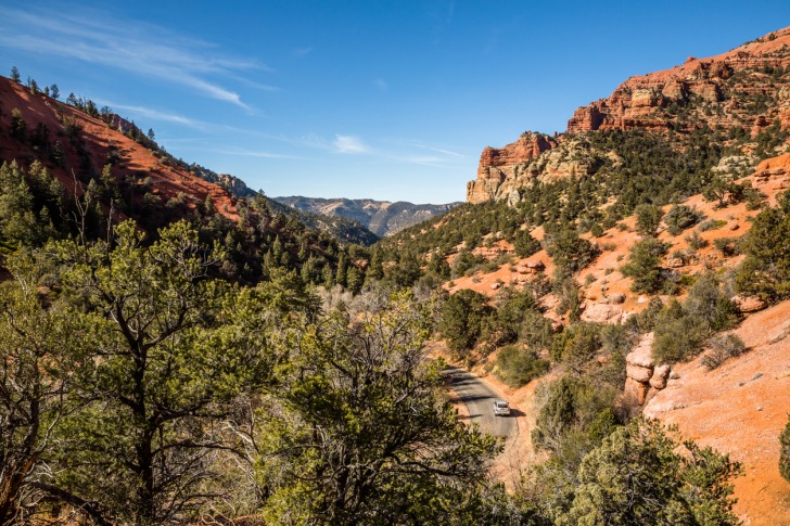
Take a scenic drive along Cedar Canyon/Route 14 from Cedar City to Alton/Highway 89.
The 40-mile drive along the plateau takes you to scenic spots like an overlook of Zion National Park, a lake formed by volcanoes, an ice cave you can explore, and Ashdown Gorge, a waterfall-filled trail that is one of the best-kept secrets.
One thing I want to clarify is the proximity to Zion National Park.
I’ve seen a few reports stating that Zion is just 20 minutes from Cedar City.
That’s true – sort of. Zion has two entrances.
The one closest to Cedar City is Kolob Canyon, a lesser-visited but just as beautiful place.
The South Entrance to Zion is about an hour from Cedar City, and that’s before you factor in the miles of traffic you can expect.
Places to Avoid in Cedar City
Cedar City doesn’t have dangerous parts of town or bad neighborhoods.
You can freely travel through public areas day or night.
Just avoid private property or gated communities if you don’t know anyone who lives there.
If you aren’t planning to visit Cedar City during one of its big events, it’s a good idea to avoid visiting during those events.
The prices of hotels and amenities will be higher, traffic will be busier, and roads will be closed off.
You can see a list of the festivals on the tourism website.
Spring might as well be called Wind Season in Southern Utah, as the gusts can range from annoying to dangerous.
The wind can also kick up dust storms that impact visibility.
Its position near mountain ranges can create wind funnels, which can make driving challenging and trails near the edge of a canyon or up on a mountain much more dangerous.
Also, while St. George and Cedar City appear to be similar in many publications, there’s a vast difference in weather.
Cedar City is 3,100 feet higher in elevation than St. George.
Safety Tips for Traveling to Cedar City
- Cedar City has a police department. You can follow them on Facebook @Cedarcitypolice. You can call 435-586-2956 if you have specific questions about safety in the community.
- Sign up for Citizen Alert emergency notifications through the Iron County Emergency Management website. You will need to enter an address, and you should use your hotel or vacation rental address since the alerts are geographically targeted. The program is free, and you can unsubscribe when you leave.
- Cedar City Police Department’s website offers a link to the Utah Crime Dashboard, where you can search for different categories of crimes or arrests. Be sure to filter the crime agency to either Cedar City Police or Iron County Sheriff. These crime data results are up-to-date, making them more recent than the official crime data from 2022 that I use in this article.
- Download the UDOT Traffic app to track road conditions across the state. You can also see live cameras, get real-time traffic updates, and see if any roads are closed before you head out.
- Review the UDOT rules for having tire chains in your car during winter weather. Some roads can’t be accessed without them. Look up Traction Law, and you should get all the information you need to get the right vehicle for winter travel in Southern Utah.
- This part of Utah is growing quickly, and more visitors are driving the roads. That’s going to mean ongoing construction, even on major thoroughfares like I-15. Expect spring and summer to have construction work ongoing, and always plan extra time when driving to a destination.
- Wildfires can happen any time of year in Southern Utah. Follow the Cedar City Fire Department on Facebook @ccfd.org to get updates on prescribed burns or new wildfires during your trip. You can also use an app like IQ Air to check air quality, as wildfires that are far away can send smoke billowing into this region.
- If you’re visiting in the winter, it’s a law that you have to clean any frost, ice, or snow off your entire windshield, hood, roof, and trunk. Don’t just scrape a spot so that you can see where you are going.
- Those renting a home should know that the law also requires fire hydrants to have several feet of space cleared out so that firefighters can easily access them in an emergency.
- If you plan to see the night skies in this remote area, please purchase a red flashlight or get a red filter to put over the flashlight. This helps prevent light pollution while still allowing you to see in the dark.
So... How Safe Is Cedar City Really?
Violent crime is down 67% since 2019 as of 2022.
The rate is 78% lower than the national average and 64% lower than the state average.
As of 2022, about two to three violent crimes happen each month, on average.
Keep in mind those rates are before the thousands of people who visit each year are factored in.
Usually, when violent crime is low, I expect property crime to be high.
That’s not the case here, with a theft rate that is 15% lower than the national average.
Property crime overall is 24% lower than the national average.
About one-third of all theft is shoplifting.
Another 28% is related to car break-ins or accessory thefts.
Those are usually fueled by people leaving vehicles unlocked, storing the keys in the unlocked car, or keeping valuables inside the car.
Several articles claim Cedar City is one of the most dangerous cities in the state.
First, Utah has one of the lowest crime rates of all 50 states, coming in at 40% below the national average.
So, even the “most dangerous city” in the state isn’t really much to worry about.
Secondly, crime data over the past few years shows all categories below national averages.
In 2019, the city had a peak of 93 violent crimes for the decade.
Even then, the violent crime rate was just 9% above the state average.
No other year since at least 2011 had a violent crime rate over the state average.
As a data journalist, I don’t crunch numbers to find sensational headlines or dismiss crime concerns that could impact tourism.
I will just tell you what the numbers say with as much context as I can provide.
For example, the violent crime data from 2018 through 2022 shows us that just 8% of violent crimes happened against strangers.
More than half (56%) happened in private homes.
That greatly lowers what little risk there is if people are concerned about tourist crime.
Cedar City is safe to visit and actually quite enjoyable for many reasons.
How Does Cedar City Compare?
| City | Safety Index |
|---|---|
| Cedar City | 86 |
| St. Louis | 58 |
| Los Angeles | 56 |
| Oakland | 57 |
| New Orleans | 57 |
| Baltimore | 56 |
| Boston | 67 |
| Sao Paulo (Brazil) | 45 |
| Rio de Janeiro (Brazil) | 43 |
| Sofia (Bulgaria) | 73 |
| Siem Reap (Cambodia) | 63 |
| Phnom Penh (Cambodia) | 61 |
| Niagara Falls (Canada) | 87 |
Useful Information

Visas
All international visitors need either a visa defining the purpose of the trip (tourist, work, school, etc.) or a visa waiver. Start the process using the Visa Wizard module on the U.S. State Department website. You’ll quickly find out which one you need. Also, keep in mind that your passport must be valid for at least six months after your trip, or you’ll need to apply for a new one.

Currency
Only the U.S. Dollar (USD) is accepted in the United States. International airports usually have a currency exchange desk on site, while regional airports won’t. Your home bank offers the lowest fees. For those using credit cards, check to see if there’s a foreign transaction fee before you start racking up charges.

Weather
Cedar City is at an elevation of 5,800 feet but still gets four robust seasons. If anything, the elevation takes the sting off the summer heat just a little bit. Highs will get into the 90s, but summer lows drop into the 50s. Bring layers of clothing to acclimate as temperatures change. Winters stay in the 40s for daytime highs, with lows in the 20s. Bring winter coats, boots, and accessories. You'll want sunscreen throughout the year.

Airports
Cedar City Regional Airport (CDC) offers flights to Salt Lake City only through Delta. You can get to St. George Regional Airport (SGU) in about an hour. You can also drive to either Las Vegas or Salt Lake City in 3–4 hours.

Travel Insurance
Comprehensive insurance offers the best protection and peace of mind. When visiting national parks and ski resorts, you'll likely have to sign a liability waiver. That means looking into travel adventure insurance might be a wise move. Rescues and air evacuation flights can add up quickly into the thousands of dollars.
Cedar City Weather Averages (Temperatures)
Average High/Low Temperature
| Temperature / Month | Jan | Feb | Mar | Apr | May | Jun | Jul | Aug | Sep | Oct | Nov | Dec |
|---|---|---|---|---|---|---|---|---|---|---|---|---|
| High °C | 6 | 8 | 13 | 17 | 22 | 29 | 32 | 30 | 26 | 19 | 12 | 6 |
| Low °C | -6 | -4 | -1 | 2 | 7 | 13 | 17 | 16 | 12 | 5 | -1 | -5 |
| High °F | 43 | 46 | 55 | 63 | 72 | 84 | 90 | 86 | 79 | 66 | 54 | 43 |
| Low °F | 21 | 25 | 30 | 36 | 45 | 55 | 63 | 61 | 54 | 41 | 30 | 23 |
Utah - Safety by City
| City | Safety Index |
|---|---|
| Bicknell | 81 |
| Brigham City | 82 |
| Bryce Canyon City | 82 |
| Cedar City | 86 |
| Green River | 83 |
| Hurricane | 83 |
| Kamas | 79 |
| Kanab | 79 |
| Layton | 81 |
| Lehi | 74 |
| Moab | 84 |
| Ogden | 72 |
| Orem | 82 |
| Panguitch | 78 |
| Park City | 78 |
| Provo | 94 |
| Salt Lake City | 55 |
| Sandy | 93 |
| St. George | 94 |
| Vernal | 83 |
| West Jordan | 94 |
| West Valley City | 65 |