 Nevada : Safety by City
- Baker
- Battle Mountain
- Beatty
- Blue Diamond
- Boulder City
- Burning Man in Black Rock City
- Caliente
- Carson City
- Elko
- Fallon
- Fernley
- Henderson
- Incline Village
- Jackpot
- Las Vegas
- Laughlin
- Lovelock
- Minden
- Moapa Valley
- Mount Charleston
- North Las Vegas
- Pahrump
- Rachel
- Reno
- Searchlight
- Sparks
- Stateline
- Tonopah
- Virginia City
- West Wendover
- Winnemucca
If the glitz, glamour, and gambling of Las Vegas aren’t enticing you to visit, there’s a perfect outdoor sanctuary for you in Blue Diamond.
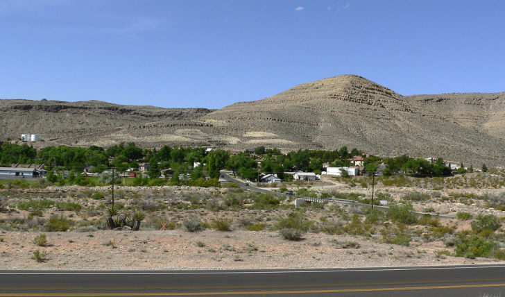
Just 30 minutes outside the Strip, you can be at the base of the Spring Mountains with many adventures in each direction.
As abruptly as the Las Vegas boundaries end, a wall of mountains approaches.
From Blue Diamond, you can take the road less traveled to Red Rock Canyon, Spring Mountain National Park, Mount Potosi, and Goodsprings.
This region made headlines in 1942 when Hollywood actress Carole Lombard died in a plane crash on Mt. Potosi (“POE-tus-see”).
Her husband, Clark Gable, waited at a nearby Goodsprings saloon for word of rescue efforts and then the unthinkable tragedy that actually happened.
That saloon is still open today.
You can also visit the oasis of a ranch in the middle of this desert at Spring Mountain Ranch.
Hiking, rock climbing, biking, and camping are popular in this area.
You’ll also avoid some of the crowds that choose the main entrance to Red Rock Canyon.
This is great Nevada outdoors, but still within quick driving distance to Las Vegas and the surrounding communities.
Warnings & Dangers in Blue Diamond

OVERALL RISK: LOW
There's a low risk here as far as crime, but wilderness safety greatly depends on your common sense, training, and preparation.

TRANSPORT & TAXIS RISK: LOW
The RTC bus system doesn't go all the way to Blue Diamond. It can get you as far as South Fort Apache Road. Taxis and rideshares are plentiful, but your own rental car is ideal. All options have a low risk.

PICKPOCKETS RISK: LOW
This is a low risk, but you should put a lot more effort into keeping your car from getting broken into. Even on the hottest summer days, don't leave windows cracked or doors unlocked. Use a sun shield on the dashboard to keep it from getting too hot inside. Put all valuables in the trunk or leave them back at the hotel.

NATURAL DISASTERS RISK: MEDIUM
There's a medium risk here, and weather can develop quickly. Winter storms aren't as common, but can make treacherous roads when it does happen. The monsoon brings thunderstorms that can develop even when the day starts crystal clear. Flash flooding and ongoing flooding can happen in the canyons and valleys of this region.

MUGGING RISK: LOW
This is another low risk. Most of the robberies happen in Pahrump on the other side of the mountain.

TERRORISM RISK: LOW
While Blue Diamond itself isn't a target, nearby Las Vegas will always be considered one of the bigger targets in the country. After the October 2017 mass shooting, security is tighter than ever.

SCAMS RISK: LOW
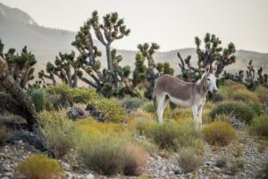
You might have a wayward burro try to scam you out of food, but there's a low risk of fraud or scams in this wilderness region.

WOMEN TRAVELERS RISK: LOW
There's just as much risk for a woman as anyone else if they aren't prepared for the outdoor conditions. The best advice is to hike in groups of three or more if you can. That's helpful in case of an emergency.

TAP WATER RISK: LOW
You'll be bringing your own drinking water here, as the public lands don't always have a supply. If you do find a water source in the parks, please let it run for a few minutes during the summer, or you'll get scalding hot water coming out.
Safest Places to Visit in Blue Diamond
The Visit Las Vegas website will have some tourist information about the region, but some of the places near Blue Diamond are hidden treasures that don’t always make the tourism guides.
It helps to know the lay of the land here.
The mountains to the west of Las Vegas are the Spring Mountains.
There’s Spring Mountain National Recreation Area.
This is flanked by U.S. 95 to the east and north and Route 160 to the south and west.
Only a small part of this designated area is closest to Blue Diamond.
Look for the Lovell Canyon location on the map to find it.
The property does expand south of Route 160 by Mountain Springs.
The visitor’s center for the national recreation area is 40 miles away on the road up to Mt. Charleston.
Spring Mountain Ranch State Park is closest to Blue Diamond.
The park includes a ranch house with tours available, or you can call ahead for a guided tour.
Living history programs are held in the spring and the fall, where people dress up like pioneers and teach guests about “the way it was.”
Several trails sprawl out in all directions.
Red Rock Canyon is accessible from Blue Diamond, and it’s under the Bureau of Land Management (BLM).
While most people approach Red Rock Canyon from Charleston Boulevard, which turns into Highway 159, that same highway curves around to meet Route 160.
You have less traffic and better access to the canyon.
Red Rock Canyon has a 22 miles scenic drive that circles the main part of the preserved land, with towering hikes or Ice Box Canyon for cooler hikes along the path.
During peak visitor season, drives on the loop are pre-scheduled.
Traffic can be bumper-to-bumper. If you want to hike more than sit in your car, look for the paths along Highway 159, where you can access the same great trails, albeit with a longer hike.
West of all those locations, you’ll be in the Rainbow Mountain Wilderness on BLM land.
South of 160, you’ll be able to hike Mt. Potosi, where the plane crashed carrying Carole Lombard.
You won’t find a memorial or exact location with a historical marker.
You can travel 40 miles to the ghost town of Goodsprings, where the Pioneer Saloon brings people in for the food, fun, and folklore.
It’s true that Clark Gable waited here for updates on the plane crash while drinking his grief away.
The legendary burns of his cigarette still mark the counter (allegedly, some dispute that claim).
There are those who believe that the ghosts of Gable and Lombard still haunt the joint, forever trying to find each other.
Of course, two other locations in the country also claim the ghosts haunt there, so who knows!
You can explore the ghost town here, go on more outdoor adventures, and tour historic buildings with a guide.
Places to Avoid in Blue Diamond
The only accommodations you’ll find here are campsites, so avoid searching for a hotel that you won’t find.
The nearest hotel is 13 miles away, near the Silverton Casino Hotel.
The Berkley high-rise hotel is also located here, with more of a condo-type setting instead of just a hotel room.
The Silverton does have a huge aquarium with mermaids (people dressed in mermaid outfits, of course) swimming.
You also have a Bass Pro Shop here for all the outdoor adventure needs.
Avoid bringing too much of your own outdoor gear if you don’t want to pay for the baggage.
In Blue Diamond, you can visit the Climbing School or Trek Bicycle Rental to get gear.
You will have a small grocery market here, but if you want to stock up, your best bet is the Albertsons at Blue Diamond and Buffalo.
That’s the last stop before you hit the open road.
This area has wild horses and burros running around, and they are protected by BLM.
There’s no imminent risk, but you should stay away from them.
Don’t feed, pet, or take a selfie with them.
Never stand behind one of them or else you could be kicked.
Safety Tips for Traveling to Blue Diamond
- Stock up your phone with numbers for BLM, the state park, National Forest, and Metro police. You might be in limited cell range when you get a signal, and the last thing you want to do is to be Googling with a draining battery on one bar of service.
- Don’t rely on phone maps to get around. Take a trail map with you (I always take a backup one sealed in a plastic bag in case the first one blows away, gets wet, or is damaged). You can also download maps onto your phone that works with GPS.
- This is a very dry climate, and sweat evaporates before you’ll even notice it. Just because you are sweating less doesn’t mean you shouldn’t stay hydrated. I always bring Liquid IV or a sports drink with me to keep electrolytes fueled. Don’t wait to drink until you are thirsty. That means dehydration is already setting in.
- Even though the water in the wild looks clean, it’s not safe to drink. Bring cleaning pellets or a filtering system that can purify the water.
- Know how to avoid and handle snakes, scorpions, and spiders. Never stick your hand down a hole, under a rock, or over the edge of a cliff. These critters like to hike in cool, dark spots. A rattlesnake will generally let you know with the signature sound before you get too close. If you are bitten, sucking the venom out can do more harm than good. Have a snake bite safety kit with you.
- You’ll be amazed at how fast the storms can form over the mountains. During the summer monsoon, storms can develop in the afternoon quickly. You don’t want to be caught outside in a storm due to lightning dangers and flash flooding risks. I had a guide who explained that rain in a desert is akin to water on a dry sponge—it rolls right off the top until it can penetrate the surface.
- As you hike along, there will be “washes,” which look like a place where streams or rivers should be. The wash should be avoided. If rain falls, or it’s during the snow melt season, water can fill those with raging currents. I saw too many people have to be rescued in Las Vegas from thinking it was “cool” to see water in the wash and jumping in, only to be carried away.
- Spring brings wildflowers to part of this region, and they are stunning to see. It is illegal to pick them. Take all the photos you want, but don’t take them or walk on them. In fact, some of the wildflowers only live a few hours or days anyway.
- Intense sunburn with second-degree burns can happen easily here. I’ve lost the skin on the backside of my shoulders just out of reach of my own hand when applying sunscreen. Always lather up, especially at you go to higher elevations.
- The sunny skies will eventually wreak havoc on your eyesight if you don’t have sunglasses. Especially as you look up the side of a mountain, you could be getting too much sunlight in your eyes. I will always have a mild spot of solar retinopathy in my right eye from a few hikes where I didn’t have glasses. That damage rarely heals.
So... How Safe Is Blue Diamond Really?
Since Blue Diamond is within a park, the biggest risks here are petty theft from vehicles, weather dangers, and lack of preparation.
If you’re searching for criminal activity closer to your visit, please know that Blue Diamond is the name of the road that leads to the Blue Diamond region.
That’s Route 160, which turns into Pahrump Valley Highway as soon as you reach Blue Diamond (the town).
If you see crimes involving Blue Diamond, it’s likely a crash or crime on the road, not in the region.
The road to Blue Diamond is a long stretch of rural paved lanes, and drivers are prone to speeding here.
I had a friend who lived in a house out here, and I always felt like I was on a raceway as I went to visit her.
Don’t follow suit for your own safety, and to avoid the police patrols that run radar on the side of the road to catch speeders.
Metro also has a “Tourist Safety” section on its website you can review to get advice and look up the “Recreate Responsibly” on the Visit Nevada site.
Between the two, you should be much more prepared for the safest trip possible to Blue Diamond, Nevada.
How Does Blue Diamond Compare?
| City | Safety Index |
|---|---|
| Blue Diamond | 76 |
| Los Angeles | 56 |
| Oakland | 57 |
| New Orleans | 57 |
| Baltimore | 56 |
| Boston | 67 |
| Washington DC | 56 |
| Siem Reap (Cambodia) | 63 |
| Phnom Penh (Cambodia) | 61 |
| Niagara Falls (Canada) | 87 |
| Calgary (Canada) | 82 |
| Buenos Aires (Argentina) | 60 |
| Vancouver (Canada) | 82 |
Useful Information

Visas
International visitors need a passport that isn't within six months of expiring and a visa or visa waiver. The U.S. State Department has a helpful Visa Wizard on its website to help start and expedite the process.

Currency
You can only use the U.S. Dollar here. The airport has a currency exchange at the international terminal, but you'll find the lowest fees at your home bank.

Weather
Dress for changing outdoor conditions here. At a higher elevation, this area is more prone to winter snow. Wear comfortable clothing with UV protection, and hiking boots with ankle support will be ideal. Sunglasses, sunscreen, and hats will help temper the sun's rays.

Airports
Harry Reid International Airport in Las Vegas is 30 minutes away. It's one of the busiest airports in the world, so you should have no trouble finding flights.

Travel Insurance
You'll want to consider travel insurance that covers all aspects of the trip, from travel by air and ground to the adventures of the mountains.
Blue Diamond Weather Averages (Temperatures)
Average High/Low Temperature
| Temperature / Month | Jan | Feb | Mar | Apr | May | Jun | Jul | Aug | Sep | Oct | Nov | Dec |
|---|---|---|---|---|---|---|---|---|---|---|---|---|
| High °C | 12 | 15 | 19 | 22 | 27 | 34 | 36 | 35 | 32 | 25 | 17 | 12 |
| Low °C | -1 | 1 | 5 | 8 | 12 | 18 | 22 | 21 | 16 | 9 | 3 | -1 |
| High °F | 54 | 59 | 66 | 72 | 81 | 93 | 97 | 95 | 90 | 77 | 63 | 54 |
| Low °F | 30 | 34 | 41 | 46 | 54 | 64 | 72 | 70 | 61 | 48 | 37 | 30 |
Nevada - Safety by City
| City | Safety Index |
|---|---|
| Baker | 74 |
| Battle Mountain | 79 |
| Beatty | 76 |
| Blue Diamond | 76 |
| Boulder City | 74 |
| Burning Man in Black Rock City | 70 |
| Caliente | 82 |
| Carson City | 77 |
| Elko | 72 |
| Fallon | 77 |
| Fernley | 77 |
| Henderson | 68 |
| Incline Village | 78 |
| Jackpot | 72 |
| Las Vegas | 62 |
| Laughlin | 75 |
| Lovelock | 76 |
| Minden | 82 |
| Moapa Valley | 78 |
| Mount Charleston | 77 |
| North Las Vegas | 54 |
| Pahrump | 74 |
| Rachel | 78 |
| Reno | 70 |
| Searchlight | 76 |
| Sparks | 77 |
| Stateline | 76 |
| Tonopah | 81 |
| Virginia City | 79 |
| West Wendover | 72 |
| Winnemucca | 73 |

I recently returned from a solo trip to Blue Diamond, and I was pleasantly surprised by the level of safety. The destination has a serene atmosphere, and the locals are respectful and helpful. I explored both popular and off-the-beaten-path areas without any issues.